All lake maps © Minnesota DNR. Learn more about lake maps
Available maps:
What do the map filenames mean?
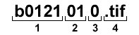
1 - Unique map identification number.
2 - Sheet number within a series of maps. A map may be made of many sheets.
3 - Revision number for this map. Larger is newer.
4 - Map file type.
TIFFs use lossless compression to maintain image integrity and clarity. Web browsers will not open TIFF files without additional image viewing software. The TIFF and PDF versions of a map contain exactly the same information.
Map Legends
Some lake maps contain detailed vegetation and substrate information. Two legend versions are available for download. Both are similar but with some variations. They include vegetation species, Latin names, and generalized substrate types. (version 1/version 2)
Commercial use of lake map data
The DNR retains copyright on these lake maps. To reproduce, republish or utilize any lake information commercially, you must file a license agreement. Please download, fill out and send the Lake Map License Agreement Form.
Send this form to:
MNIT @ DNR Fisheries
500 Lafayette Road
St. Paul, MN 55155-4025.
About the lake map images
All lake maps show areas within Minnesota. They were compiled from the 1930s to the 1990s. No guarantees are made to their quality and accuracy, including locations of public accesses.