Per Hatlevik and Heather Moor are meticulously outfitted for their mission. Both wear hiking boots, brimmed hats, and rugged pants. Hatlevik sports a GPS device on a lanyard around his neck. His multi-pocketed vest and Moor's daypack are filled with what they call their "tools of the trade." Today this includes a nine-volt battery, gloves, and a gel heat pack, although it is a warm morning. Despite these trappings of intrigue, Hatlevik and Moor are not thieves or spies. They are geocachers.We rendezvous in
Lebanon Hills Regional Park, south of St. Paul, for today's operation, dubbed Fire and Ice by its mastermind. We will follow coordinates that Hatlevik downloaded into his GPS unit from
Geocaching.com. If successful, we will find our way to a weather-tight container holding the contents of a prototypical geocache: A logbook to sign and date and trinkets to trade. If we take a trinket, we'll also leave one.
Article continues below sidebar
Geo Lingo
Geocachers love their lingo.
Geobeacon is an object or landmark that signals the cache may be nearby. Geocaching is often referred to simply as
the game, as if it were the only one that mattered. (Earth itself is the game board.)Didn't find your cache? You
DNF'd it. You were the first to find one? Well,
FTF to you. Cribbing the name for nonwizards from the Harry Potter books, geocachers derisively term noncachers
Muggles. One of the worst fates for a cache is to be
Muggled—removed, damaged, or destroyed by the clueless.
In addition to following latitudinal and longitudinal coordinates, some geocaching hunts require the seeker to solve puzzles or riddles, break codes, or employ special equipment. Fire and Ice is one of these more elaborate types.As we walk a gravel trail, red-winged blackbirds and dragonflies flit over a pond aside a sublime oak-savannalike landscape. The morning breeze carries the pungent pollens of late summer and an air of mystery as the GPS arrow shows the way.
Thousands of Caches.
More than 28,000 geocaches are hidden around Minnesota, including hundreds in state parks and thousands in our state and national forests. They are tucked away along state trails, on county and municipal parklands, and in the margins of urban environments. You've doubtless passed by many.Hatlevik and Moor show me a cache hidden inside a well-disguised fake rock. They lead me to another, dubbed Troll, lurking under a footbridge. I've heard tales of caches tethered underwater, out on a tree limb, and inside a puppet.Not just any cache can be placed anywhere. Rules vary depending on who manages the land. On state-owned land, most restrictions are aimed at preventing damage to natural resources and historical or archaeological sites. Cachers going off-trail can disrupt flora or fauna or introduce invasive species. And caches that are large or intrusive can diminish the nature experience.Who hides geocaches? Often they are geocachers who've taken on the role for their peers. "We really value our hiders," says Hatlevik, citing one Minnesotan for his especially voluminous and creative hides. Ian Stevens of Minneapolis, who goes by the geocaching name King Boreas, has hidden more than 4,500 caches, nearly all of them in Minnesota. To mark his 63rd birthday two years ago, he celebrated by hiding 63 caches that day.Stevens used to look for the treasure medallion hidden as part of the St. Paul Winter Carnival—an annual search that ends the moment the coin is found. Then in 2001 he read a newspaper story about a new activity—geocaching. "I thought, this is something I can go do anytime," he says. His sons gave him a GPS for Father's Day, and he got swept up in the hobby.Stevens is particularly fond of state forests, where he has hosted special events for geocachers to get together and camp, hike, socialize, and, almost incidentally, find a few caches. "To me the fun of it is what goes on between cache finds," he says.
Waypoint by Waypoint.
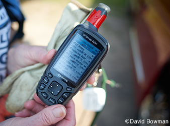
At Lebanon Hills, Hatlevik and Moor find the first Fire and Ice waypoint: a dog tag dangling from a limb about 7 feet up a trailside elm. Hatlevik plugs coordinates from the tag into his GPS. For this multistage cache, each waypoint offers a clue to the next. The coordinates take us farther down the path and then the GPS arrow swings toward a narrow footpath leading into the grass. We follow it to a gray utility-type box on a short post. A notice on the padlocked front panel reads: "Geoclimate monitoring station."Hatlevik and Moor have done their advance work by reading the description of Fire and Ice on Geocaching.com. It specified a nine-volt battery, a tool to create heat or cold, and a three-number password. Moor correctly infers that this number is the padlock combination. She pops the lock and opens the access panel to encounter an LED display and a dangling battery plug. She connects the battery, and the display comes to life. The message: "In order to find the next stage, 40 degrees hotter or colder is all that is required."Moor pulls out the preheated gel pack and holds it tightly around a metal rod attached to the box—a temperature probe, it turns out. Within minutes the display flashes "Congratulations!" followed by coordinates to the next waypoint.We soon ascend a grassy knoll and find the cache, a steel military ammunition box hidden under sticks between a tree and a boulder. Hatlevik signs the log and leaves a small metal "geotag" with a QR code, which can be read by a smartphone. Each successive finder of the tag, he hopes, will relocate it to a new cache and report its travels to Geocaching.com. Hatlevik once left a tag that ended up at a huge geocaching event in Germany.
Forest Loop
On a clear August day, I meet Barb and Patrick Garin and Norvina Schaper for a morning of geocaching at
Sand Dunes State Forest near Zimmerman. Patrick unfolds a map and traces a route we'll drive on the forest's rustic gravel roads, looping past more than a dozen caches, most of them rated "easy" on the five-point scale used by geocachers.While state park caches stick close to maintained trails, forest caches can be off in the brush. Schaper and the Garins know how to bushwhack through heavy cover, deal with burrs and bugs, and stay hydrated. Most important, they never rely entirely on the GPS. Electronics can fail, so they always carry map and compass backup.Heat waves rise off the sandy soil, releasing the resinous scent of red pines. Over the next several hours, fueled by cold water and Schaper's homemade chocolate chip cookies, we traverse the sand dunes of the forest."I'm a fair-weather cacher. He's an obsessive cacher," Barb says."The fun definition of geocaching is that we use billion-dollar military satellites to find Tupperware hidden in the woods," Patrick tells me."You have people from all walks of life doing this," Schaper says.Many of our cache forays give us close-up views of the forest, whose light soil failed for farming but now supports planted pine and oak. One search takes us through a firewood cutting area where people gather oak. Another leads us into a soggy lowland, where edible hedgehog mushrooms thrive. All morning, we swap stories, soak in the scenery, and rack up cache after cache.
State Park Demo
Norvina Schaper has been to all 75 of
Minnesota's state parks and recreation areas twice, and most of them three times, to find caches of the state park geocaching program. All state parks, most state recreation areas, and seven state trails have rolled out a new program, Call of the Wildflowers, which encourages parkgoers to find as many of the 81 caches as they can over three years while learning about a different flower at each one.Novice geocachers needn't be digital whizzes, wear multipocketed vests, or even own a GPS if they go to certain state parks. Thirty-four state parks offer loaner units along with basics tips and, in some cases, free Geocaching 101 classes to get newbies started.For some park visitors, geocaching answers the common question, "What can we do here?" It offers a destination, a challenge, and a way to explore a new landscape together. This is what has drawn Pam and Eric Baukol of Montevideo to Geocaching 101 at
Jay Cooke State Park. Their children, Nels, 7, Patrick, 5, and Thea, 2, are naturally squirmy as naturalist Carly Hawkinson explains GPS satellite technology. "We're going to be playing with outer space today," she tells them. After some basics, they all head out to find treasures in the park. The rapids of the nearby St. Louis River thrum with a low roar as the kids scatter."I got it!" shouts Patrick as he plucks a plastic jar from under a footbridge. Nels gently picks a slug off the jar and puts it on his arm. Thea wanders around with a GPS unit, following her own internal arrow while pretending to play the game. By the time they're done, the kids have puzzle pieces that collectively form before-and-after pictures of the park's Swinging Bridge, which was destroyed by a flood in 2012 and recently rebuilt.Inspired by the experience, the family plans to hunt for more caches later in the day.I appreciate the allure of geocaching as a family activity. For several years, my 9-year-old has worn around his neck a cord featuring a molded metal dragon. He's vowed not to remove the necklace "never ever." It was inside one of the first geocaches our family found during a summer camping vacation. He's not always the most gung-ho geocacher, but he clings to this found object as a talisman. Though he can't exactly explain the keepsake's appeal, I have my own theory: It tells the story of a day out together, as a family, far from home and work and school, exploring a world of hidden wonders.