Drought is defined as a period of abnormally dry and/or unusually hot weather sufficiently prolonged for the corresponding deficiency of water to cause a serious hydrologic imbalance.
When a serious hydrologic imbalance occurs, soil moisture reserves, groundwater supplies, lake levels and stream flows are negatively impacted. Water-dependent industries including agriculture, public utilities, forestry and tourism are profoundly affected.
Some degree of drought occurs in Minnesota nearly every year. The 2021 drought was the most severe in Minnesota since at least 1988.
Careful stewardship of Minnesota's water resources is always important. During drought, water resources are particularly stressed and water conservation measures are especially important.
Current drought conditions in Minnesota
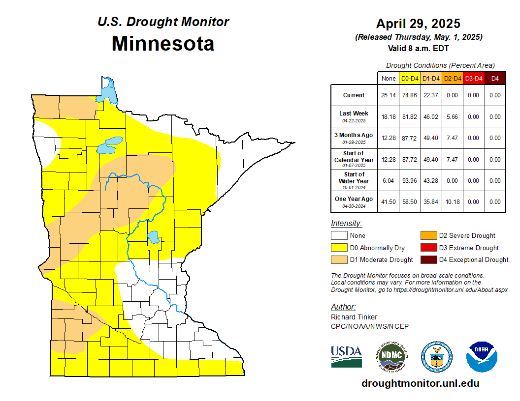
(Note: reload/refresh browser to ensure the current map is displayed. This webpage is updated each Friday from March through October during active drought.)
Drought management actions
The Minnesota Statewide Drought Plan applies drought phases to the 12 river basin watersheds in the state (HUC4 level).
The following basins remain in the Drought Watch phase:
Rainy River Watershed
Mississippi Headwaters Watershed
St. Croix Watershed
Missouri Little Sioux Watershed
Missouri Bix Sioux Watershed
Des Moines Watershed
Minnesota Watershed

Watersheds in the Drought Warning Phase, public water suppliers are required to implement water conservation measures, with the goal of reducing water consumption to no more than 150% of January levels. For watersheds in the Drought Restrictive Phase, public water suppliers are required to implement water conservation measures, with the goal of reducing water consumption to no more than 125% of January levels.
Drought conditions typically lead to increased irrigation for crops, lawns and athletic fields, which leads to additional strain on Minnesota’s water resources. Moderate drought (D1) is characterized by dry soil conditions, stressed crops, and lower than average river and lake levels. Severe drought (D2) is characterized by much lower-than-average river and lake levels hard ground and a higher potential for severe impacts on agriculture. Extreme drought (D3) may result in early harvest of corn and increased risk of wildfires. In exceptional drought (D4), early harvest of corn and emergency haying and grazing are typical, surface waters are near record lows and wildfires may be widespread.
Well interference
The well interference webpage provides information on what to do if you run out of water and the formal complaint process.
Stream flow
Stream flow maps and tables are updated each Monday and summarize stream flow conditions throughout Minnesota.
Surface water appropriations are contingent upon stream flows in the HUC8 level watersheds (as opposed to the larger HUC4 watersheds that are used for Drought Phase specification).
Minnesota statute requires the DNR to limit consumptive appropriations of surface water under minimum flow conditions to protect instream ecology and downstream public water supplies. Water use types considered for suspension include irrigation, dust control, sand and gravel washing, and construction non-dewatering. Permits for public drinking water are not suspended.
The DNR will continue to monitor flows and water levels in watersheds throughout the state and will temporarily suspend surface water appropriations when needed to protect in-stream flows, downstream higher priority users, and fish and wildlife habitat.
Mississippi River Dam
Real-time streamflow compared to historical stream flow for the day of the year maps should be consulted for the most up to date information.
Fire danger and management
Drought conditions can also increase fire danger and can trigger varying degrees of burning restrictions across all of Minnesota. Fire danger and burning restrictions maps are updated daily and should be consulted for the most up to date information.
Lake water levels
The Hydrologic Conditions Report is prepared monthly and has general information concerning various water resources across Minnesota.
Precipitation forecast
For updated precipitation forecast, see the NOAA National Prediction Center quantitative 5-day precipitation forecast.
How rainfall and snowfall impact drought conditions
Soils are more efficiently replenished by multiple rainfall events than by any single heavy rainfall event. Surface water and groundwater respond somewhat differently over time. It is also important to note that annual precipitation averages vary widely across Minnesota, from less than 19 inches in northwestern Minnesota to 32 inches in the southeastern corner of the state.
Droughts frequently persist from one year to the next, depending in part on precipitation in winter and, to a greater extent, spring. A deep late-winter snow pack, frozen soil which prohibits infiltration, rapid snow melt and heavy early spring precipitation can rapidly shift concerns from drought to potential flooding.
See the latest Drought Conditions Report.
Sign up for updates
What happens in drought restrictive phase
When watersheds enter the drought restrictive phase, the DNR and others take additional steps, including:
Notifying water appropriators with DNR permits that they should minimize non-essential water uses and follow water conservation measures, such as reducing landscape irrigation, using more efficient irrigation equipment, and checking for and repairing water leaks. Water appropriation permit holders can contact the local DNR area hydrologist for technical assistance or with any questions.
Notifying public water suppliers within these watersheds to implement water use reduction actions with a goal of reducing water use to 25% above January levels. Residents, businesses and landowners should watch for communications from their municipal or public water supplier for details on local water use reduction actions and restrictions. Restrictions on non-essential water uses (such as outdoor irrigation, car washes, etc.) may be enacted as public water suppliers take steps to achieve water reduction goals.
Increasing public awareness of drought conditions.
State Drought Task Force
The DNR convenes the State Drought Task Force in Drought Warning phase. The primary purposes of the Task Force are information sharing, coordination and planning.
Per the Minnesota Statewide Drought Plan, the DNR determines state drought phases and responses based on specific climatological and water data. Task Force members may share information and perspectives regarding these factors, but making phase determinations is not a role of the Task Force.
Permit suspensions during low flow

Related to drought conditions, but not part of the State Drought Plan, is the requirement to protect instream uses and downstream public water supplies during periods of low flow.
The majority of watersheds in the state have a long-term water gauge that allows the DNR to monitor flow rates. The data collected from these gauges is utilized to quantify base flows as well as peak and low flow conditions. DNR staff continually monitor the flows in these major watersheds to determine when the low flow threshold has been reached. The threshold is based on statistical analysis that calculates what is called the Q90 flow. The Q90 value indicates that 90% of the time in recent decades, stream flow has been greater than that value. In other words, the stream flow has only been that level or below 10% of the time. Q90 is considered protected low flow level in Minnesota and is used for suspending surface water appropriations.
Drought conditions sometimes result in watersheds falling below the low flow threshold that triggers suspension of surface water appropriations. The DNR notifies permit holders when their permits are suspended and when they are reinstated.
The DNR’s surface water suspension guidelines identify the many factors that need to be considered for both permit suspension and permit reinstatement. The variability of these natural systems requires a holistic approach that can incorporate a broad array of inputs as part of decision-making. At a minimum, river flows need to above the minimum flow (Q90) for three consecutive days, but not just slightly above the minimum. The flow must be high enough so all surface appropriations do not reduce the flow back below the minimum flow. Precipitation forecasts are also considered when determining whether permits should be re-instated. These careful evaluations help to avoid re-suspending permits shortly after having them reinstated. That pattern would not be good for the aquatic ecosystem and could create frustration or confusion for permit holders.
Low lake levels and river flows
Water level fluctuations are natural. Occasional low water levels can be beneficial to ecosystems, but they can affect people, recreation and businesses that are dependent on water.
Lake and river levels are dependent on the amount of precipitation an area receives, how much of that moisture is contributed by runoff, how much water is recharged or discharged through groundwater, and how much water evaporates.
Very few lakes and rivers are regulated by water control structures. For those situations where control structures are present, they are operated according to the authorized project purposes and associated operating plans for those structures.
Manipulation of lake levels, such as adding or removing stop logs at lake outlets, requires DNR authorization under a public water works permit. Any unauthorized lake level manipulation is illegal.
Water appropriation permits that withdraw water directly from lakes are subject to suspension when lake levels go below specified protective elevations.
What can I do?
Take active measures to reduce indoor and outdoor water use. Ideas include avoiding lawn watering, addressing any plumbing leaks, and running only full loads in your washing machine and dishwasher.
Longer range options include investing in water efficient appliances and installing drought tolerant landscaping.
Residents and landowners should watch for communications from their municipal or public water supplier for details on local water use reduction actions and restrictions.
For additional ideas to conserve water please see DNR’s water conservation webpage.