Ecological Land Classification Hierarchy
The Minnesota Department of Natural Resources and the U.S. Forest Service have developed an Ecological Classification System (ECS) for ecological mapping and landscape classification in Minnesota following the National Hierarchical Framework of Ecological Units (ECOMAP 1993). Ecological land classifications are used to identify, describe, and map progressively smaller areas of land with increasingly uniform ecological features. The system uses associations of biotic and environmental factors, including climate, geology, topography, soils, hydrology, and vegetation. ECS mapping enables resource managers to consider ecological patterns for areas as large as North America or as small as a single timber stand and identify areas with similar management opportunities or constraints relative to that scale. There are eight levels of ECS units in the United States. Map units for six of these levels occur in Minnesota: Provinces, Sections, Subsections, Land Type Associations, Land Types, and Land Type Phases. The first three levels are described here.
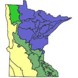
Provinces are units of land defined using major climate zones, native vegetation, and biomes such as prairies, deciduous forests, or boreal forests. There are 4 Provinces in Minnesota. Printable map of provinces

Sections are units within Provinces that are defined by origin of glacial deposits, regional elevation, distribution of plants, and regional climate. Minnesota has 10 sections. Printable map of sections

Subsections are units within Sections that are defined using glacial deposition processes, surface bedrock formations, local climate, topographic relief, and the distribution of plants, especially trees. Minnesota has 26 subsections. Printable map of subsections
Land Type Associations are units within Subsections that are defined using glacial landforms, bedrock types, topographic roughness, lake and stream distributions, wetland patterns, depth to ground water table, soil parent material, and pre-European settlement vegetation . Minnesota has 291 land type associations. Though not described here, a GIS cover of land type associations is available on the Minnesota Geospatial Commons.
Land Types are units within Land Type Associations that are defined using pre-European settlement vegetation , historic disturbance regime, associations of native plant communities (the System level of Native Plant Community Classification), wetland distribution, and soil types. Land Type maps have been made for the Chippewa National Forest.
Land Type Phases are units within Land Types that are defined using a native plant community class, soil type, and topography. Land Type Phase maps exist for portions of the Chippewa National Forest and several State Parks.