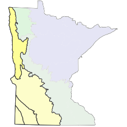
The Red River Valley Section (RRV) is formed predominantly of a single landform, the deep-water basin of Glacial Lake Agassiz. The basin is a nearly featureless plain with poorly drained silty and clayey soils. Low, sinuous beach ridges and wave-cut scarps mark the position of former shorelines of Glacial Lake Agassiz along the eastern margin of the basin. The section is drained by the Red River and a system of tributaries with shallow, poorly developed valleys that create the only topography in the section.The RRV is the flattest, driest, most fire-prone region of Minnesota and for that reason was historically dominated by communities of the Upland Prairie and Wetland Prairie systems, which covered more than 90% of the section. Wooded communities were present only in the deepest river valleys, on narrow patches of upland between river valleys, and along the eastern edge of the section where the flat Agassiz basin abuts rugged stagnation moraines. In these areas, fire-dependant forest/woodland, mesic hardwood forest, wet forest, and floodplain forest communities were present together in small patches and accounted for less than 5% of the vegetation. Marsh and wet meadow communities were present on river bottoms and shallow depressions, especially along the eastern edge of the section.

Subsections are units within Sections that are defined using glacial deposition processes, surface bedrock formations, local climate, topographic relief, and the distribution of plants, especially trees. Minnesota has 26 subsections. Printable map of subsections