State Climatology Office - DNR Division of Ecological and Water Resources, St. Paul
Distributed: April 5, 2024
What happened in March 2024:
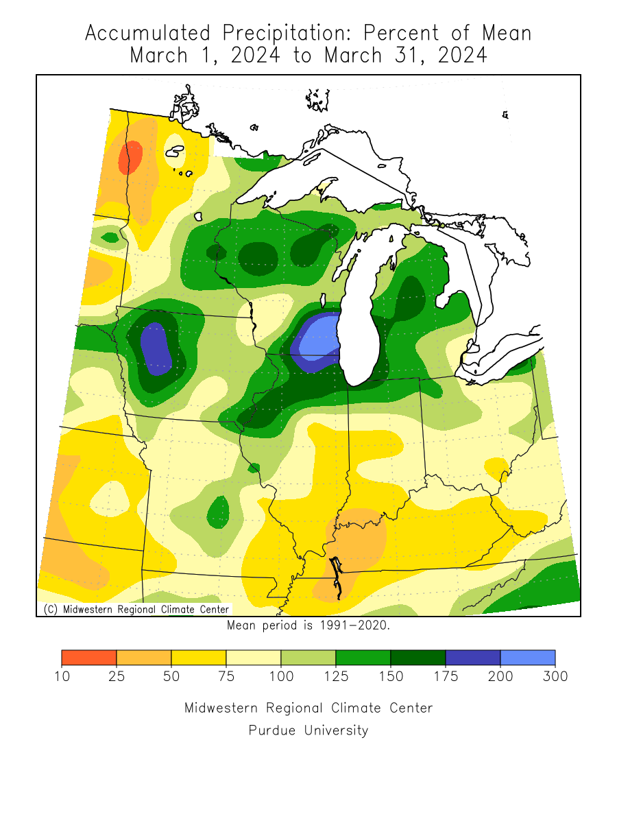
- Just like December 2023 was defined by a singular precipitation event, March 2024 was similar with the “Revenge of the Lost Winter” event of March 23-27. This singular event boosted statewide March precipitation values above normal. The statewide average total was 1.57 inches, or .08 hundredths above the 1991-2020 normal. The highest total found so far was 3.12 inches at Red Wing or 1.22 inches above normal. One of the driest locations was .32 inches at Lake Bronson Dam in Kittson County.
[see: March 2024 Precipitation Total Map | March 2024 Precipitation Departure Map | March 2024 Climate Summary Table | March 2024 Percent of Normal Precipitation Map] - There were two main precipitation events in March 2024. A band of moderate snow, with a narrow strip of heavier snowfall rates, affected central and southeastern Minnesota from the afternoon on Thursday March 21st, into early Friday March 22nd, 2024. Accumulations were generally 2-5 inches, but areas near St. Cloud, Big Lake, Zimmerman, St. Francis, and Chisago City reported 6-8 inches.
[see: Central and Southeast Minnesota Snow, March 21-22, 2024] - On March 23-27 a powerful winter storm lashed Minnesota with heavy snow, slush, rain, a few thunderstorms, and strong winds. This major storm produced multiple waves of precipitation, leading to by far the largest snowfall event of the 2023-24 winter, and a season's worth of precipitation in some areas.
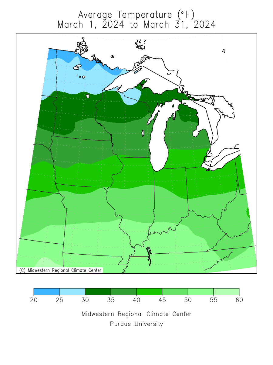
[see: Revenge of the Lost Winter: March 23-27, 2024 Storm] - March 2024 warmer than March 2023 by nine degrees and continued the above normal statewide temperature pattern that began in August 2023. The preliminary statewide average for March 2024 was22.6 degrees or 3.4 degrees above normal. The warmest temperature found was 78 degrees at Theilman in southeast Minnesota on March 4 and the coldest temperature was -17 degrees F at Orr in northeast Minnesota on March 1. [see: Minnesota Climate Trends | March climate Summary Table | 2024 March Temperature Map]
Where we stand now:
- Winter was fleeting and sporadic in March, with the first half of the month behaving more like April and the last half a little closer to a typical March. Finally, there was a decent snow cover for the final week of the month for some late season winter recreation. By April 4, much of the snows of March had melted away.
[see: MNDNR April Snow Depth Maps | NWS Snow Depth Estimation Map] - The U. S. Drought Monitor map released on April 4, 2024 depicts 98.6% of the state with some level of drought designation. Last year at this time, 49% of the state had some level of dryness indicator. On April 4, 2024 about 55% of the state was Abnormally Dry, 32% of the state in Moderate Drought conditions and 11% state in Severe Drought conditions. A wet second half of March improved the drought information some over the southern half of the state. The U.S. Drought Monitor index is a blend of science and subjectivity where drought categories (Moderate, Severe, etc.) are based on several indicators.
[see: Drought Conditions Overview] - The nearly non-existent snow pack and the continuing drought situation caused a very low flood risk this season statewide.
[see: Statewide USGS Stream Flow Conditions | Central Minnesota Rivers | Southeast Minnesota Rivers | Northwest Minnesota Rivers, including the Red River - Water levels on most Minnesota lakes vary depending on lake and location. A preliminary Minnetonka level was at 928.82 feet on April 4, with Grays Bay Dam closed. Minnetonka is a half-foot higher compared to April, 2023, and is a foot higher than in September. White Bear Lake had a preliminary level of 922.08 feet on April 5 and is 1.65 feet lower than April 2023. . Rainy Lake was in the median band and Lake of the Woods was on the low end of the median range for early April. Lake Superior was forecasted to be at 601.12 feet on March 29, eight inches lower than last year at this time and one inch below the long term monthly average for March.
[see:;Lake Minnetonka Water Level | White Bear Lake Water Level | Lake of the Woods Control Board Basin Data | Corps of Engineers Great Lakes Water Levels] - In its first report of the 2024 growing season, the Agricultural Statistics Service reported that topsoil moisture across Minnesota was 16 percent Very Short, 22 percent Short, 57 percent Adequate, and 2 percent Surplus. 6% of the oat crop was planted, three weeks ahead of last year and two weeks ahead of the five year average.
[see: Agricultural Statistics Service Crop Progress and Condition] - Before the snow and the rain of the second half of March, fire danger was elevated in the state. Cooler weather helped to temper the danger a bit at the end of the month. The potential for wildfires on April 4 is rated by DNR as Moderate over the west and east central parts of Minnesota and Low over the northeast, north central and southeast.
[see: Fire Danger Rating Map] - Lake ice out began in earnest at the end of February to the beginning of March. The first lake to lose its ice in the state was Lake Okamanpeedan in Martin County on the Iowa border on February 22. Some lakes set new record dates for early lake ice out. There are only four lakes in the state with records back to 1878. Two of these were broken. Clear Lake in Waseca County has records back to 1874, and 2024 set a new record ice out. The old record was March 6, 1878 and that record was broken this year with the new record of March 1. Osakis set a new early ice out record of March 8, which broke the very old record of March 13, 1878. While not as long of a record as some lakes, White Bear Lake set a new lake ice out record of March 8,breaking the old record of March 19, 2012.In general, in March, lake ice out was about a month ahead of the long-term averages. Cooler weather for the last week of March and the first week of April put a break on lake ice out.
[see: 2024 Lake Ice-Out Dates | DNR Conservation Officer Reports]
Future prospects:
- The April precipitation outlook indicates equal chances of below, normal and above-normal values across the entire state. Normal April precipitation ranges 1.5 inches in northwest Minnesota to around three inches in southeast counties. The historical probability of measurable precipitation for any given day in April ranges from 20 percent in the far northwest to 35 percent in the southeast.
[see: Climate Prediction Center 30-day Outlook | April Precipitation Normal Map] - The April temperature outlook has a fairly high confidence for above normal temperatures in the state. Normal April high temperatures are in the mid to upper 40s early in the month, rising to the low 60s by month's end. Early-April normal low temperatures are near 20 in the north, near 30 in the south. By month's end, low temperatures average in the mid-30s in the north, near 40 in the south.
[see: Climate Prediction Center 30-day Outlook | April Temperature Normal Map] - The 90-day precipitation outlook indicates equal chances of below, normal and above normal precipitation from April-June over the state. The April through June temperature projection favors above normal conditions over the state, mainly because of the warm April outlook.
[see: Climate Prediction Center 90-day Outlook]
From the author:
Minnesota is still in an El Niño pattern with a transition to an ENSO-Neutral pattern by April-June and about a 75% chance of a La Niña developing June-August. Looking at past strong El Niño patterns that are transitioning to La Niña, there are cases of an active weather season, including 1983, 1998 and 2016. There was one notable exception with the hot and dry summer of 1988.
[see: ENSO Outlook ]
Upcoming dates of note:
- April 18: National Weather Service releases 30/90 day temperature and precipitation outlooks
![]() Subscribe to email announcements of the monthly posting of this product.
Subscribe to email announcements of the monthly posting of this product.
Pete Boulay MNDNR Climatologist