State Climatology Office - DNR Division of Ecological and Water Resources, St. Paul
Distributed: April 13, 2023
What happened in March 2023:
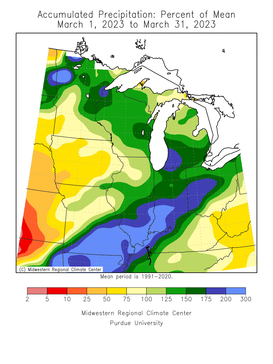
- March monthly precipitation totals were generally above normal across east central and either side of a line from Fargo to Duluth, otherwise, the rest of the state was near to below normal, especially along the Iowa border. The largest precipitation total found so far was 3.89 inches from New Hope in the Twin Cities, which included some of the precipitation from the March 31-April 1 rain and snowstorm. Ada in northwest Minnesota saw 3.77 inches of precipitation, or 2.76 inches above normal. One of the drier locations was .66 inches at Minneota in southwest Minnesota or .54 inches short of normal. The preliminary average statewide precipitation was 1.80 inches or .32 inches above normal.
[see: March 2023 Precipitation Total Map | March 2023 Precipitation Departure Map | March 2023 Climate Summary Table | March 2023 Percent of Normal Precipitation Map] - There were four main weather systems that affected the state in March 2023. The first event affected mainly western, central and northern Minnesota from February 28 to March 1. Kragnes and Moorhead in Clay County both reported 14 inches and Dilworth reported 12 inches.
[see: Western and Northern Minnesota Heavy Snow, February 28 - March 1, 2023] - The second event was the wet, heavy snow event on March 5-6, 2023. A medium-strength winter weather system produced several inches of wet, sticky, and heavy snow from southwestern through east-central Minnesota.
[see: Wet, Heavy Snow, March 5-6, 2023] - The third event was a different type of storm, a super-sized Alberta Clipper. A swath of central and northern Minnesota, reaching as far south as Rush City and as far north as Lutsen and East Grand Forks, received at least eight inches of snow, but many areas had a foot or more. A long strip near the north shore of Lake Superior was hit the hardest, with numerous totals of 14 to 18 inches, including 18.5 inches at a CoCoRaHS station to the west of Two Harbors, 17.1 inches measured by the National Weather Service Cooperative observer 7 miles northwest of Two Harbors, 16 inches at Finland, 14.3 inches at Silver Bay, and 13-16 inches reported in and around Duluth. Officially, the Duluth National Weather Service recorded 12.5 inches of snow.
[see: The March 11-12, 2023 "Super-Duper Clipper"] - Yet another winter storm brought rain, sleet, heavy snow, and gusty winds to Minnesota on Thursday March 16th, 2023, lingering into Friday March 17th. Heavier snow was confined to a narrow band from southwest to northeast from Sioux Falls through the St. Cloud area and northeast to Hibbing and Duluth. Some of the higher totals reported to the National Weather Service was 5 inches at St. Cloud and 6.4 inches at Onamia. The highest total found so far was 7.3 inches near the town of Payne in St. Louis County.
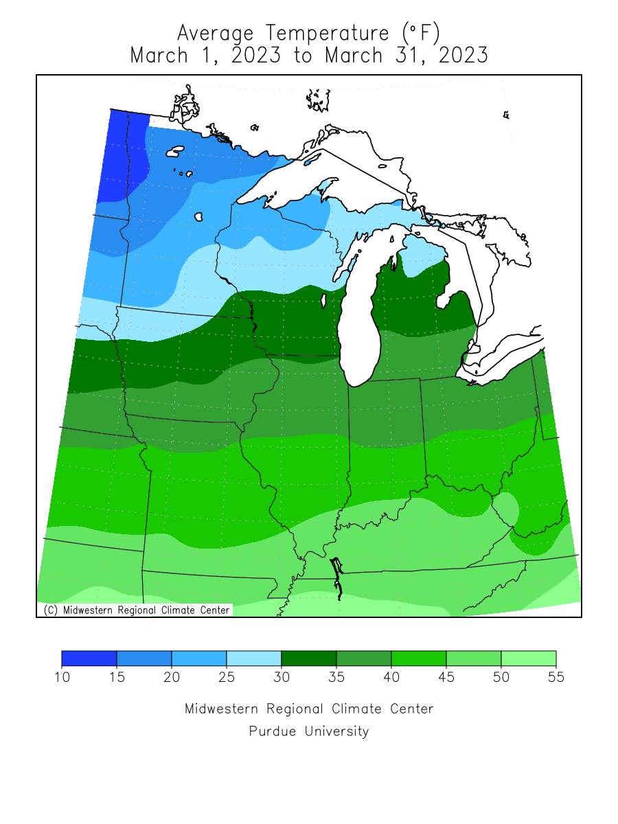
[see: Heavy Wintry Precipitation and Strong Winds, March 16-17, 2023] - 2023 was the second March in a row that finished with below normal temperatures, and was the coldest March since 2014. The preliminary statewide average was 22.6 degrees or six degrees below formal. The warmest temperature found was 54 degrees at Rushford in southeast Minnesota on the 26th and the coldest temperature was -22 degrees F at Ada in northwest Minnesota on the 29th and 30th. [see: Minnesota Climate Trends | March climate Summary Table | 2023 March Temperature Map]
Where we stand now:
- Winter overstayed its welcome in early April. However, Summer made an early appearance during the second week of April and rapidly eroded the snowpack.
[see: MNDNR April Snow Depth Maps | NWS Snow Depth Estimation Map | Midwest Regional Climate Center Snow Depth Map] - The U. S. Drought Monitor map released on April 13, 2023 depicts 49% of the state with some level of drought designation. Last year at this time, 41% of the state had some level of dryness indicator. On April 13, 2023 about 49% of the state was Abnormally Dry, and 9% of the state in Moderate Drought conditions. Generally wet conditions over the winter and early spring has continued the gradual improvement. The U.S. Drought Monitor index is a blend of science and subjectivity where drought categories (Moderate, Severe, etc.) are based on several indicators.
[see: Drought Conditions Overview] - The deep snowpack of the winter of 2022-23 contributed to a higher risk of spring flooding across the state. The rapid melting of the snowpack sent water quickly to rivers and streams. There was not widespread significant rainfall for the first half of April and that has helped the flood situation somewhat. Many streams in the central and south are above to much above normal with normal flow in the north.
[see: Statewide USGS Stream Flow Conditions | Central Minnesota Rivers | Southeast Minnesota Rivers | Northwest Minnesota Rivers, including the Red River - Water levels on most Minnesota lakes vary depending on lake and location. A preliminary Minnetonka level was at 928.33 feet on April 13, with Grays Bay Dam closed. Minnetonka has risen a foot since early November. White Bear Lake had a preliminary level of 923.73 feet on April 13. Rainy Lake and Lake of the Woods were both on the low end of the median range for early April. Lake Superior was forecasted to be at 601.77 feet on April 7, six inches higher than the long-term monthly average for April.
[see:;Lake Minnetonka Water Level | White Bear Lake Water Level | Lake of the Woods Control Board Basin Data | Corps of Engineers Great Lakes Water Levels] - In its second report of the 2023 growing season, the Agricultural Statistics Service reported that topsoil moisture across Minnesota was 4 percent Very Short, 7 percent Short, 69 percent Adequate, and 20 percent Surplus. More storms had added to snow-covered fields and no fieldwork was completed.
[see: Agricultural Statistics Service Crop Progress and Condition] - The hot, dry and windy weather conditions have elevated fire danger in the state, especially where the snowpack is gone. The potential for wildfires on April 13 is rated by DNR Forestry as Extreme over southeast Minnesota, Very High over south central and southwest Minnesota, as well as east central Minnesota. The fire danger is Moderate over west central Minnesota and Low over the north.
[see: Fire Danger Rating Map] - The start of lake ice out was delayed from seven to ten days in the far south, but with the record warm conditions, the progress of lake ice out has proceeded rapidly.
[see: 2023 Lake Ice-Out Dates | DNR Conservation Officer Reports]
Future prospects:
- The April precipitation outlook indicates a greater than average chances of above-normal values across the entire state, with the best chance in the northeast. Normal April precipitation ranges 1.5 inches in northwest Minnesota to around three inches in southeast counties. The historical probability of measurable precipitation for any given day in April ranges from 20 percent in the far northwest to 35 percent in the southeast.
[see: Climate Prediction Center 30-day Outlook | April Precipitation Normal Map] - The April temperature outlook has a tilt to below normal temperatures in the state. Normal April high temperatures are in the mid to upper 40s early in the month, rising to the low 60s by month's end. Early-April normal low temperatures are near 20 in the north, near 30 in the south. By month's end, low temperatures average in the mid-30s in the north, near 40 in the south.
[see: Climate Prediction Center 30-day Outlook | April Temperature Normal Map] - The 90-day precipitation outlook indicates equal chances of below, normal and above normal precipitation from April-June over southwest and west central Minnesota with a tendency of above normal precipitation in the east and north. The April through June temperature projection favors below normal conditions over the northwest, north central and central with equal chances over the south and the northeast.
[see: Climate Prediction Center 90-day Outlook]
From the author:
The first red-winged blackbird (with its song) arrived in Maplewood on March 20, the latest since 2019 and four days later than last year. The first western chorus frog song was heard on April 10, only one day later than last year, but eighteen days later than 2021.
[see: Signs of Spring: Phenology ]
Upcoming dates of note:
- April 20: National Weather Service releases 30/90 day temperature and precipitation outlooks
![]() Subscribe to email announcements of the monthly posting of this product.
Subscribe to email announcements of the monthly posting of this product.
Pete Boulay MNDNR Climatologist