State Climatology Office - DNR Division of Ecological and Water Resources, St. Paul
Distributed: April 10, 2026
What happened in March 2026:
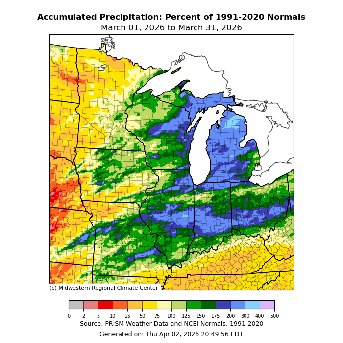
March lived up to its name as a transition month, featuring two blizzards and a surge of summer-like air as well. Southwest Minnesota continued to miss out on the heaviest precipitation with a preliminary average for March 2026 winding up .53 inches short of normal. On the other side of the spectrum, southeast Minnesota was .68 inches above normal. Overall the state was close to normal precipitation, with a preliminary total of 1.30 inches or .13 inches short of normal. The highest total found so far was 3.11 inches at Austin in Mower County. One of the drier locations was in northwest Minnesota at Ada with .32 inches of precipitation or .69 inches short of normal.
[see: March 2026 Precipitation Total Map | March 2026 Precipitation Departure Map | March 2026 Climate Summary Table | March 2026 Percent of Normal Precipitation Map]There were two significant precipitation events in March 2026, and two during the first week of April 2026. The first one in March was a feisty “Alberta Clipper” system. This compact but powerful weather system brought heavy snow and blizzard conditions to northwestern and northeastern parts of Minnesota, while intense winds, lashed western, central, and southern parts of the state. Wind gusts were clocked to 78 mph at Florence, to the southwest of Marshall, and over a dozen stations recorded gusts of 70 mph or higher. Other gusts of 50 to 65 mph were recorded throughout other parts of central and southern Minnesota. The Twin Cities airport recorded a gust to 61 mph, and both Rochester and New Ulm recorded 63 mph gusts. These were the strongest winds not associated with thunderstorms in Minnesota since December 15, 2021 which was an odd night with both extreme thunderstorm winds and extreme non-thunderstorm winds.
[see: Extreme Winds and Winter Storm, March 12-13, 2026 ]On Saturday and Sunday, March 14-15, 2026, a powerful regional winter storm lashed southern Minnesota with heavy snow, sleet, isolated thunderstorms, and strong winds, leading to some of the state's largest snowfall totals observed away from Lake Superior in the last decade, along with impossible travel from whiteout conditions and widespread school cancellations.;
[see: Mid-March 2026 Extreme Snow and Blizzard ]Back-to-back storm systems struck Minnesota during the first four days of April 2026, with areas of sleet, freezing rain, rain, thunderstorms, and even heavy snow. Much of the state received over an inch of precipitation from the two storms, and parts of northwestern Minnesota received a foot-and-half of snow. This was the second year in a row and the third time in four years that a slushy, wet, and (in some areas) very snowy storm system played an April Fools' prank on parts of Minnesota.
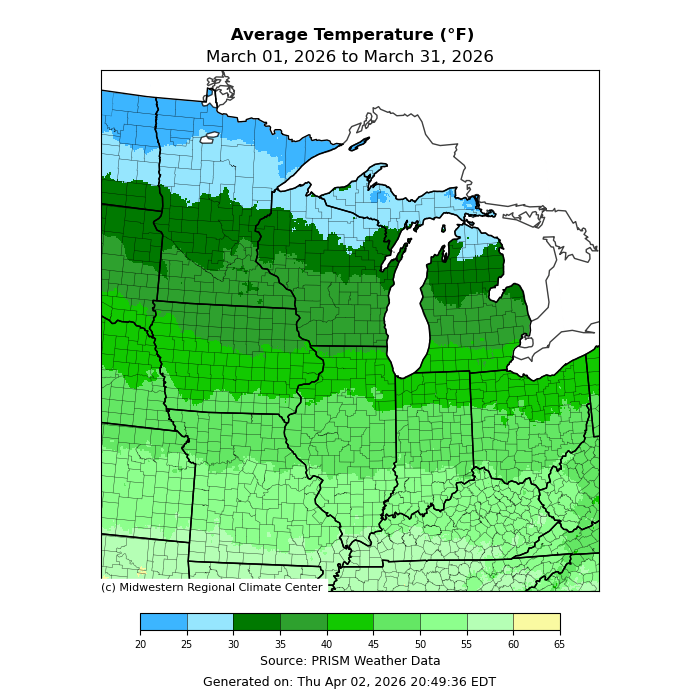
[see: Twin Spring Storm Systems, April 1-4, 2026 ]March 2026 was the third March a row with warmer than normal temperatures. The preliminary statewide average for March 2026 was 32.2 degrees, or 3.9 degrees above normal. The warmest temperature found so far was 85 degrees at Pipestone in Pipestone County on March 21 and the coldest temperature found so far was -30 at both Indus and 10 miles northwest of Gunflint Lake on March 1. [see: Minnesota Climate Trends | March climate Summary Table | 2026 March Temperature Map]
A surge of intense early-season heat brought the warmest conditions since October to southern and western Minnesota, along with the earliest 85-degree F high temperature on record anywhere in the state.
[see: Record Warmth, March 21, 2026 ]
Where we stand now:
The snowstorm over Easter Weekend gave a boost the snowpack over northern Minnesota. By April 9, this too had eroded quite a bit. The deepest snow is along the North Shore away from Lake Superior.
[see: MNDNR April Snow Depth Maps | NWS Snow Depth Estimation Map]The U. S. Drought Monitor map released on April 9, 2026 depicts 58% of the state with some level of drought designation. Last year at this time, 90% of the state had some level of dryness indicator. On April 9, 2026 about 31% of the state was Abnormally Dry, 24% of the state in Moderate Drought conditions and 2% state in Severe Drought conditions. A wet beginning of April improved the drought situation somewhat over the state. The U.S. Drought Monitor index is a blend of science and subjectivity where drought categories (Moderate, Severe, etc.) are based on several indicators.
[see: Drought Conditions Overview]With a fairly meager snow pack for the winter of 2025-2026, there wasn’t much runoff due to melt. Most of the stream flow reports in the state range from below average to above average. The highest stream flows are in the southeast part of the state.
[see: Minnesota USGS Stream Flow Conditions | Southeast Minnesota Rivers | Northwest Minnesota Rivers, including the Red RiverWater levels on most Minnesota lakes vary depending on lake and location. Minnetonka was at 929.02 ft on April 10, very close to the same level last year at the time. White Bear Lake had a preliminary level of 923.16 922.64ft, .52 tenths of a foot higher than April 2025. Rainy Lake was in the median band and Lake of the Woods was on the low end of the median range for early April. Lake Superior was forecast to be at 600.98 feet on April 9, three inches higher from last year at this time and very close to the long-term monthly average for April.
[see:;Lake Minnetonka Water Level | White Bear Lake Water Level | Lake of the Woods Control Board Basin Data | Corps of Engineers Great Lakes Water Levels]In its first report of the 2026 growing season, the Agricultural Statistics Service reported on April 5 that topsoil moisture across Minnesota was 2 percent Very Short, 19 percent Short, 59 percent Adequate, and 7 percent Surplus. In the first measurement of the season, soil moisture at Lamberton is above historical averages.
[see: Agricultural Statistics Service Crop Progress and Condition | U. of M. Southwest Research & Outreach Center (Lamberton)]Fire danger has been elevated at times over the past few weeks, depending on the weather conditions of the day. The potential for wildfires on April 10 is rated by DNR as Moderate over the southern, and east central parts of Minnesota and Low over the north, central, and west central.
[see: Fire Danger Rating Map]Lake ice out began in the far south, about two weeks ahead of the median. The first lakes to lose their ice for the 2026 season were the lakes in Lake Shetek State Park in Murray County with Lake Shetek losing its ice on March 2. White Bear Lake lost its ice on March 31, two weeks ahead of the median and Minnetonka on April 3, ten days ahead of the median. Cooler temperatures in April slowed progress a bit.
[see: 2026 Lake Ice-Out Dates | DNR Conservation Officer Reports]
Future prospects:
The April precipitation outlook indicates a tilt to above normal precipitation, especially over eastern Minnesota. Normal April precipitation ranges 1.5 inches in northwest Minnesota to around three inches in southeast counties. The historical probability of measurable precipitation for any given day in April ranges from 20 percent in the far northwest to 35 percent in the southeast.
[see: Climate Prediction Center 30-day Outlook | April Precipitation Normal Map]The April temperature outlook is a three-sided coin showing equal chances of below, normal and above-normal values across the entire state, except the far southwest where there is a slight tendency for above normal temperatures. Normal April high temperatures are in the mid to upper 40s early in the month, rising to the low 60s by month's end. Early-April normal low temperatures are near 20 in the north, near 30 in the south. By month's end, low temperatures average in the mid-30s in the north, near 40 in the south.
[see: Climate Prediction Center 30-day Outlook | April Temperature Normal Map]The 90-day precipitation outlook indicates equal chances of below, normal and above normal precipitation from April-June over the state. The April through June temperature projection also has equal chances of below normal and above normal temperatures, with the southwest corner seeing a tilt to above normal temperatures.
[see: Climate Prediction Center 90-day Outlook]
From the author:
The La Niña pattern is expected to transition to an ENSO-Neutral pattern this spring and there’s about a 55% chance of an ENSO-Neutral pattern persisting though the summer. For October-December 2026 there’s about an 80% chance of El Niño conditions, with the possibility of a strong El Niño developing.
[see: ENSO Outlook ]
Upcoming dates of note:
April 16: National Weather Service releases 30/90 day temperature and precipitation outlooks
![]() Subscribe to email announcements of the monthly posting of this product.
Subscribe to email announcements of the monthly posting of this product.
Pete Boulay MNDNR Climatologist