HydroClim Minnesota for Early May 2022
A monthly electronic newsletter summarizing Minnesota's climate conditions and the resulting impact on water resources. Distributed on the first Thursday of the month.
State Climatology Office - DNR Division of Ecological and Water Resources, St. Paul
distributed: May 12, 2022
What happened in April 2022:
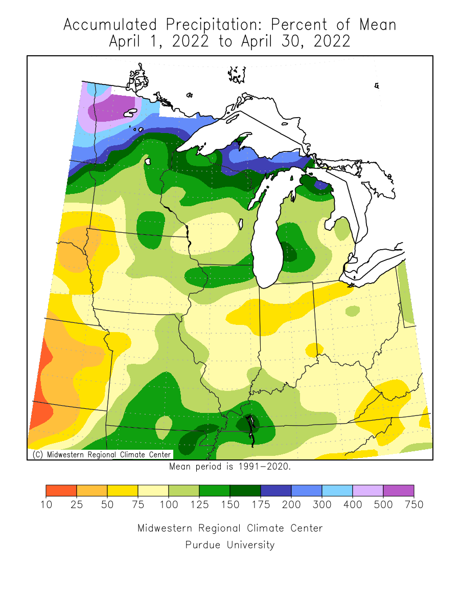
- April 2022 was a cool, cloudy, rainy, and a sometimes snowy month. The wettest area of the state was in the northwest and north central, with another higher area of precipitation in the southeast. The driest locations were in the southwest. The highest precipitation total found so far by an observer from the National Weather Service was 8.67 inches at Thorhult in Beltrami County in northwest Minnesota. International Falls in north central Minnesota set a record April precipitation total of 7.61 inches, 5.97 inches above normal. The driest spot was near Lakefield in Jackson County in southwest Minnesota or 1.08 inches below normal. The preliminary statewide average was 3.73 inches or .88 inches above normal. It was the 7th wettest April on record, going back to 1895.
[see: April 2022 Precipitation Total Map | April 2022 Precipitation Departure Map | April 2022 Climate Summary Table | April 2022 Percent of Normal Precipitation Map] - April 2022 was a continuation of the active month of March with multiple precipitation events. The first one was a large Alberta Clipper that brought precipitation to large part of the state, with over half the state seeing significant precipitation. Parts of the northeast Minnesota saw over an inch.
[see: More Rain, Snow, and Wind, April 5-7, 2022 ] - For the 4th week in a row, another large storm system hit Minnesota, this one brought severe thunderstorms and caused severe damage in Taopi MN located in Mower County near the Iowa border. Grand Meadow wound up with 3.05 inches and there was brief flooding at Whitewater State Park.
[see: April 12-14: Severe Thunderstorms, Snow, and Wind] - The latest in a series of large weather systems produced waves of rain and thunderstorms across Minnesota on April 22-24, with heavy rains drenching parts of the northwest, hail and strong winds reported in the southeast, and a small tornado reported near Crookston. As has been the case frequently this spring, very strong winds swept across Minnesota, lasting for over 24 hours.
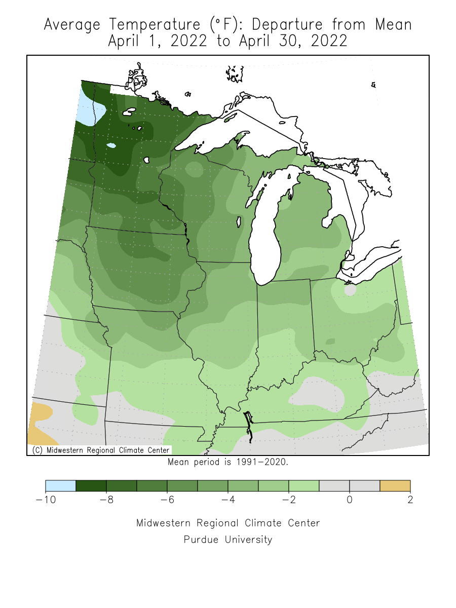
[see: Strong thunderstorms, rain, and wind - April 22-24, 2022] - for the 4th month in a row, April finished with below normal temperatures. There was one very warm day on the 23rd that gave the south half of the state their first 70 degree temperature of the year. Nonetheless, the average statewide April temperature was 5.5 degrees below normal, or the tenth coldest April on record going back to 1895. The highest temperature found was 80 degrees on April 23rd at Milan in west central Minnesota and the lowest temperature found was 5 degrees below zero east of Ely in northeast Minnesota.
[see: April 2022 Climate Summary Table | 2022 April Departure from Normal Temperature Map
Where we stand now:
- Seasonal precipitation totals so far (April 1 through May 10) ranked well above the historical median over the central and north, with large areas of northwest Minnesota in the 98th percentile for the period. Precipitation is below the median over southwest Minnesota.
[see: Seasonal Precipitation, Percent Normal and Ranking Maps] - The final snow depth map of the season was produced on April 28, as the state's snowpack persisted over the north. International Falls had its last measurable snow on the ground on April 28. By early May, what snow remained was confined to the higher elevation areas away from Lake Superior. There were still people skiing at Lutsen on May 7. [see: Snow Depth Maps]
- The wet April continued to ease the drought situation and on May 3, less than 7% of the state had any kind of drought indicator on the US. Drought Monitor, mostly confined to the south west and south central parts of the state. On May 3, 2022, about 6% of the state was Abnormally Dry, and .1% of the state in Moderate Drought conditions, confined to the far south central part of the state. The U.S. Drought Monitor index is a blend of science and subjectivity where drought categories (Moderate, Severe, etc.) are based on several indicators.
[see: Drought Conditions Overview] - The U.S. Geological Survey reports that stream discharge values are generally much above normal across the state, with some streams near normal in the southeast. There are high stream flows in the Red River Valley.
[see:USGS Stream Flow Conditions] - Water levels on most Minnesota lakes vary depending on lake and location in the state. The Mille Lacs lake level for early May was just above the median. The ice left Mille Lacs on May 2, about three weeks later than last year and a week later than the median. On May 12, Minnetonka was at 929.13 feet. White Bear Lake was at 924.17 on May 12, (.4) four tenths of a foot lower than last year. With the exceedingly wet April, Lake of the Woods was above its 95th percentile for May 11th with 1061.04 feet. This is 2.25 feet higher than the median of 1058.79 feet. Rainy Lake was at 1109.11 feet or 2.30 feet above the median on May 11. Lake Superior was forecast to be at 601.57 feet on May 6, six inches lower than the monthly average for early May and six inches lower than early May 2022.
[see: Mille Lacs Lake Water Level | Lake Minnetonka Water Level | White Bear Lake Water Level | Lake of the Woods Control Board Basin Data | Corps of Engineers Great Lakes Water Levels] - The cool and soggy April and start to May hindered crop planting. As of May 9, 9% of the corn crop was planted, compared to 81 percent last year and the 5 year average of 48 percent. The Agricultural Statistics Service reported on May 9 that topsoil moisture supplies across Minnesota are 1 percent Very Short, 4 percent Short, 69 percent Adequate, and 16 percent Surplus.
[see: Agricultural Statistics Service Crop Progress and Condition] - There was a delay in the spring fire season, but activity began to pick up in early May with warmer conditions. The wet pattern continues to suppress fire danger. The potential for wildfires on May 12, rated by DNR Forestry as ranging from Low to Moderate over much of the state.
[see: Fire Danger Rating Map] - Progress of lake ice out in general has been sluggish, with occasional warm and windy conditions sprinkled in to speed up the progress. Lake ice out began on a few days behind the median in the south. Progress fell farther behind in April. Minnetonka lost its ice on April 15, two days later than the median while Bemidji lagged two weeks behind the median and shed its ice on May 8. By May 12, ice was confined to the far northern Minnesota Lakes.
[see: 2022 Lake Ice-Out Dates | DNR Conservation Officer Reports]
Future prospects:
- The May precipitation outlook has the same wet pattern continuing for the month with a fairly strong tendency for above normal precipitation . May precipitation normals range from just over two inches in northwest Minnesota to just less than four inches in southeastern counties. The historical probability of measurable precipitation for any given day in May ranges from 25 percent in the northwest to near 40 percent in the southeast.
[see: Climate Prediction Center 30-day Outlook | May Precipitation Normal Map] - The May temperature outlook has a tendency for below normal temperatures, which was true for the first week of May, the second week was much above normal. Normal May high temperatures are in the low to mid-60s early in the month, rising to the low to mid-70s at month's end. Normal May low temperatures are in the mid-30s to near 40 to start the month, and climb to the mid-40s to low 50s as the month ends.
[see: Climate Prediction Center 30-day Outlook | May Temperature Normal Map] - The 90-day precipitation outlook for May through July indicates equal chances of below-normal, near-normal, or above-normal conditions across the central and north, with a tendency for below normal precipitation in the south. The May through July temperature projection shows equal chances of below-normal, near-normal, or above-normal temperatures for all but the far southwest, where there is a tilt for above normal temperatures.
[see: Climate Prediction Center 90-day Outlook] - The National Weather Service produces long-range probabilistic river stage and discharge outlooks for the Red River, Minnesota River, and Mississippi River basins. These products address both high flow and low flow probabilities.
[see: National Weather Service - North Central River Forecast Center]
From the author:
- April was a very gloomy. Along with a three-way tie for the 14th coldest April on record for the Twin Cities, and the 17th wettest, there was also plenty of gloom to go around. In the sixty year history of the U of M St. Paul Campus Climate Observatory, April 2022 was the gloomiest April on record with 312.7 Langleys per day. The average from 1963-2021 is 395.5 Langleys per day. A Langley is a unit of solar radiation measured as one gram calorie per square centimeter of a surface exposed to solar radiation.
[see: Windy, Cloudy, Cold, Wet (and Snowy) April ]
Upcoming dates of note:
- May 19: National Weather Service releases 30/90 day temperature and precipitation outlooks
![]() Subscribe to email announcements of the monthly posting of this product.
Subscribe to email announcements of the monthly posting of this product.
Pete Boulay, DNR Climatologist