A monthly electronic newsletter summarizing Minnesota's climate conditions and the resulting impact on water resources. Distributed on the first Thursday of the month.
State Climatology Office - DNR Division of Ecological and Water Resources, St. Paul
distributed: May 7, 2026
What happened in April 2026:
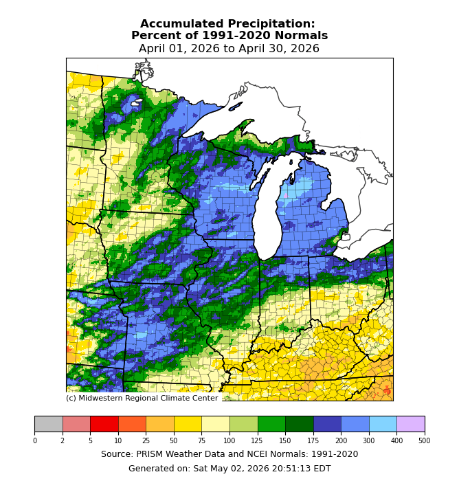
April had some wild weather. The month started off with two storm systems for the first four days with 2-4 inches of precipitation in the southeast and a foot or more of snow at Moorhead, Bemidji and Thief River Falls. On April 13th another storm system brought the first tornadoes of the year for Minnesota. Four tornadoes were reported in south central Minnesota. However, the most impactful tornado event was April 17, when five tornadoes struck southeast Minnesota with two of them reaching EF2 in scale (111-135 mph). Four of the tornadoes were in Olmstead County. The wettest areas of the state were in northeast and southeast Minnesota. Caledonia in southeast Minnesota had 6.42 inches of precipitation or 2.46 inches above normal. Two Harbors 7NW had the highest total found so far in the state with 7.04 inches or 4.14 inches above normal. One of the drier locations was at Milan in Chippewa County with 1.75 inches or .75 inches below normal. The preliminary statewide average was 3.59 inches or .87 inches above normal.
[see: April 2026 Precipitation Total Map | April 2026 Precipitation Departure Map | April 2026 Climate Summary Table | April 2026 Percent of Normal Precipitation Map]There were a number of storm events during the month of April. Back-to-back storm systems struck Minnesota during the first four days of April 2026, with areas of sleet, freezing rain, rain, thunderstorms, and even heavy snow. Much of the state received over an inch of precipitation from the two storms, and parts of northwestern Minnesota received a foot-and-half of snow.
[see: Twin Spring Storm Systems, April 1-4, 2026]Intense thunderstorms rumbled across southern Minnesota on Monday April 13, 2026, producing the state's first tornadoes of the year along with a swath of damaging hail.[see: Minnesota's First Tornadoes of the Year, April 13, 2026 ]
Five tornadoes struck southeastern Minnesota as an outbreak of severe weather affected a large part of the region on Friday April 17, 2026. One particularly strong supercell produced five different confirmed tornadoes in the Rochester area, with two to the southwest, one to the south, one to the northeast, and one to the east. [see: Tornadoes of April 17, 2026 ]
The last week of April 2026 featured a long duration soggy rain event that put a dent in the drought but also caused flooding in northeast Minnesota with elevated water levels on lakes in the Boundary Waters. Many reports of one to two inches were common over a period of three days from April 26 to 28th in a swath from southwest Minnesota to northeast parts of the state. The rain fell in two parts. Rain associated with a cold front affected the state on the 25th and 26. A large area of low pressure moved from western Iowa on the 27th to northern Lake Superior by the 28th and dumped the heaviest rain. Most of Minnesota saw a half inch of precipitation or more, the only area that missed out was in the far northwest.. [see: Soaking Rains in Minnesota for the Last Week of April 2026.]
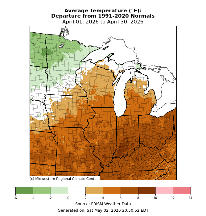
For the third year in a row, April finished above normal for temperatures. Overall, the average statewide temperature for April finished .4 degrees above normal. Northwest Minnesota averaged below normal for the April, and southeast Minnesota averaged with above normal temperatures. There was a wide range in temperatures for the month. The warmest temperature found so far was 93 degrees at Milan and Madison in west central Minnesota on April 22, and the coldest temperature found so far was -6 degrees at Mahnomen on April 6.
[see: April 2026 Climate Summary Table | 2026 April Departure from Normal Temperature Map
Where we stand now:
Seasonal precipitation totals so far (April 1 through May 5) ranked well above the historical median over the northeast and southeast, with pockets of below the median in west central and northwest Minnesota. Much of eastern St. Louis, lake and Cook County were in the top ten wettest for the past 50 years.
[see: Seasonal Precipitation, Percent Normal and Ranking Maps]The final snow depth map of the season was produced on April 16, as the last of the state's snowpack was confined to the highlands above Superior. International Falls had its last measurable snow on the ground on April 11, Duluth had its last measurable snow on the ground on April 13. [see: Snow Depth Maps]
Over the past couple weeks, there’s been improvement in the drought situation for the state. On the map released on May 7, 70% of the state was free of any drought designation. 23% of the state was Abnormally Dry and 7% of the state was in Moderate Drought conditions and a tiny sliver (.4%) in southwest Minnesota in Severe Drought conditions. The U.S. Drought Monitor index is a blend of science and subjectivity where drought categories (Moderate, Severe, etc.) are based on several indicators.
[see: Drought Conditions Overview]The heavy rains of the last week of April meant a big change in stream flows over much of the state. On May 5, most streams were normal to high flows over the central and the south, and some rivers flooding in the northeast, like the Kawishiwi River near Ely, the Pigeon River at Grand Portage and the Basswood River at Winton. There were a few exceptions to the higher flows, like the Straight River near Park Rapids and the Mississippi at Bemidji were very low for the time of year.
[see: Cooperative Stream Gauging | USGS Stream Flow Conditions]Water levels on most Minnesota lakes vary depending on lake and location in the state. On May 7, Mille Lacs was at 10.78 feet, about three tenths of a foot lower than this time last year and about a half foot below the median. The official lake ice out for Mille Lacs was April 21, three days earlier than the median of April 24, and a few days later than in 2025. On May 1, the lake level of Minnetonka was at 929.21 feet, nearly the same as this time last year. There were 12 cfs flowing out of Grey’s Bay Dam. White Bear Lake was at 923.18 feet on May 7, 1.12 feet below the outflow level. Lake of the Woods is in the middle of the median band and Rainy Lake is in the upper end of the median band for early May. Lake Superior on May 6 was 601.57 feet, about three inches higher than last year at this time.
[see: Mille Lacs Lake Water Level | Lake Minnetonka Water Level | White Bear Lake Water Level | Lake of the Woods Control Board Basin Data | Corps of Engineers Great Lakes Water Levels]As of May 3, 42 percent of the corn was planted, about 1% ahead of last year and 11% ahead of the 5 year average. The Agricultural Statistics Service reported on May 3 that topsoil moisture supplies across Minnesota are 2 percent Very Short, 20 percent Short, 67 percent Adequate, and 11 percent Surplus. In the May 1, 2026, measurement, soil moisture at Lamberton is above historical averages by about ¾ of an inch. [see: Agricultural Statistics Service Crop Progress and Condition | U. of M. Southwest Research & Outreach Center (Lamberton)]
With the dry and sunny weather over the past week, the fire danger is elevated over much of the state and on May 7 is rated Low only over the far north central. Moderate in the southeast, northeast and northwest, and High across much of central and southern Minnesota . Historically, 80 percent of all wildfires in Minnesota occur during April and May.
[see: Fire Danger Rating Map]Lake ice out for 2026 started about ten days to two weeks ahead of the median in southern Minnesota. The first lakes to lose their ice were in southwest Minnesota with Lake Shetek losing its ice on March 8, a full three weeks earlier than the median of April 3. White Bear Lake lost its ice on March 31, Twelve days earlier than the median and Lake Minnetonka was declared “ice out” on April 3, nine days earlier than the median. Somewhat cooler temperatures arrive in April and into May and this slowed the progress of lake ice out a bit. Mille Lacs was declared out on April 21, three days early and Lake Vermilion lost its ice on April 28, two days earlier than the median. By May 7, there was still ice on Lake of the Woods and some of the Boundary Waters lakes.
[see: 2026 Lake Ice-Out Dates | DNR Conservation Officer Reports]
Future prospects:
The May precipitation outlook shows that there will be a tilt toward drier than normal conditions across the state., especially in central and southern Minnesota. May precipitation normals range from just over two inches in northwest Minnesota to just less than four inches in southeastern counties. The historical probability of measurable precipitation for any given day in May ranges from 25 percent in the northwest to near 40 percent in the southeast.
[see: Climate Prediction Center 30-day Outlook | May Precipitation Normal Map]The May temperature outlook has a tendency for below normal temperatures in the northeast third of the state, the rest of the state has equal chances for below, normal and above normal temperatures. Normal May high temperatures are in the low to mid-60s early in the month, rising to the low to mid-70s at month's end. Normal May low temperatures are in the mid-30s to near 40 to start the month, and climb to the mid-40s to low 50s as the month ends.
[see: Climate Prediction Center 30-day Outlook | May Temperature Normal Map]The 90-day temperature and precipitation outlook for May through July indicates equal chances of below-normal, near-normal, or above-normal conditions across the state.
[see: Climate Prediction Center 90-day Outlook]The National Weather Service produces long-range probabilistic river stage and discharge outlooks for the Red River, Minnesota River, and Mississippi River basins. These products address both high flow and low flow probabilities.
[see: National Weather Service - North Central River Forecast Center]
From the author:
So far this spring Phenology has been a bit ahead of schedule. In Maplewood, north of St. Paul the first chorus frogs were heard on April 8, two days earlier than last year. The first dandelions were spotted in St. Paul on April 17, as week earlier than last year. April 25 with crabapples were in full bloom by May 5th, with lilacs by May 7, a week earlier than last year. The cooler temperatures prolonged the blooms.
[see: Signs of Spring: Phenology ]
Upcoming dates of note:
May 14: National Weather Service releases 30/90 day temperature and precipitation outlooks
![]() Subscribe to email announcements of the monthly posting of this product.
Subscribe to email announcements of the monthly posting of this product.
Pete BoulayDNR Climatologist