State Climatology Office - DNR Division of Ecological and Water Resources, St. Paul
Distributed: April 8, 2022
What happened in March 2022:
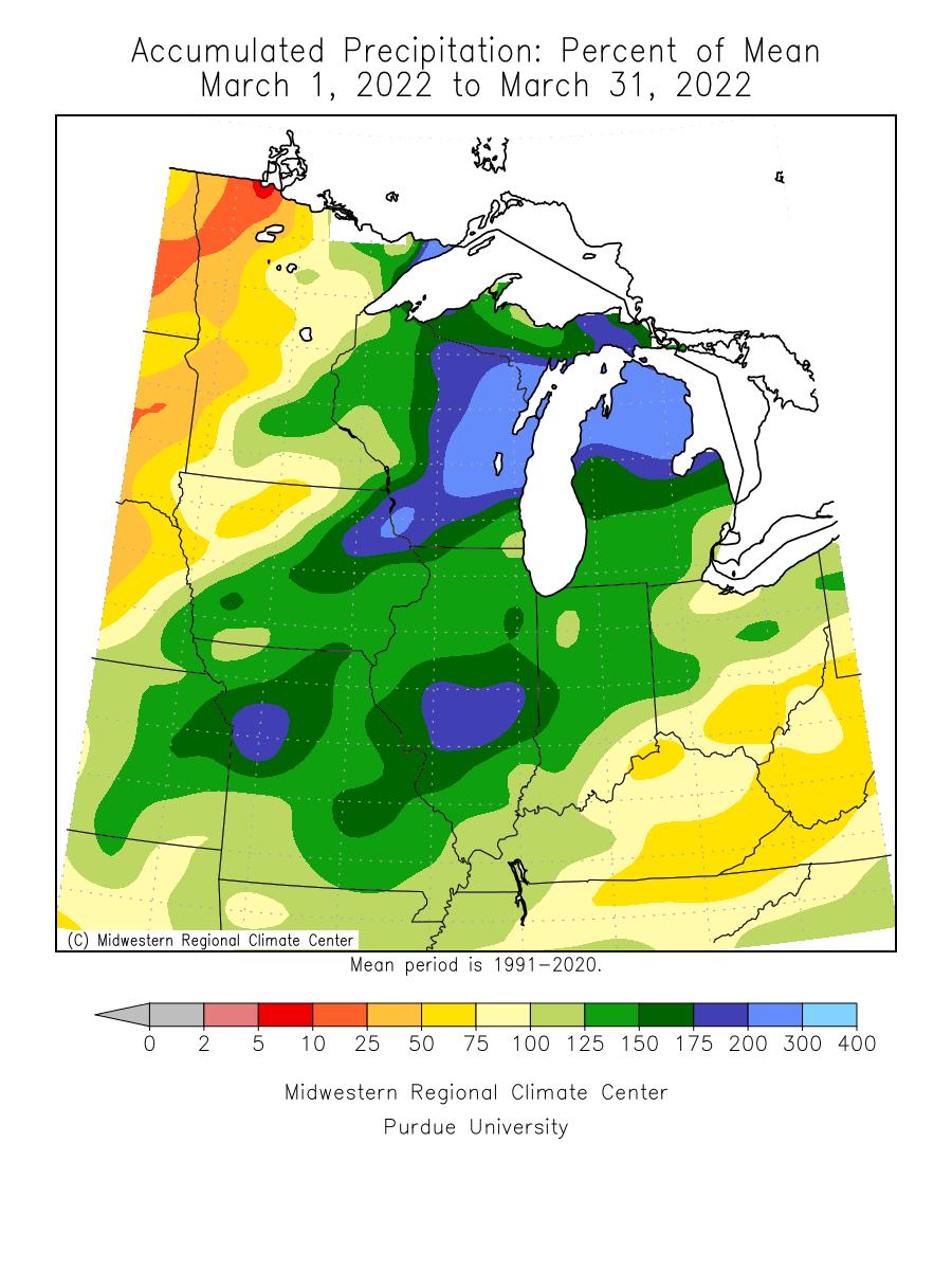
- March monthly precipitation totals were generally above normal across the south and east, and below normal in the west. The wettest areas were in the eastern Twin Cities Metro area and in Cook County. There were a couple of heavy precipitation events during the month. The first was on the 5th-6th and another on the 21st-23rd and a final event on the 29th-30th. The Twin Cities International Airport saw 2.95 inches for the month or 1.27 inches above normal. An observer in Mahtomedi in Washington County saw 3.43 inches of precipitation. One of the drier locations was in west central Minnesota with Benson only seeing .08 inch or 1.42 inches short of normal. The preliminary average statewide precipitation was 1.40 inches or .09 inches below normal.
[see: March 2022 Precipitation Total Map | March 2022 Precipitation Departure Map | March 2022 Climate Summary Table | March 2022 Percent of Normal Precipitation Map] - There were three main weather systems that affected the state in March 2022. The first was a messy spring storm on March 5-6 that brought a mix of freezing rain, sleet, and thunderstorms to much of Minnesota, with a quick barrage of extremely heavy snow in some areas as a final act.
[see: Messy Spring Storm and Unusual Snow Burst, March 5-6, 2022] - The second event was on March 21-23 that brought steady rains to southern and eastern Minnesota, with freezing rain, sleet and heavy snow falling over the northern and northeastern parts of the state. Areas around Mankato, Rochester, and the Twin Cities received over an inch of precipitation, with a half-inch or more falling over the southeastern 60% of the state, basically south and east of a line from Worthington, to Leech Lake, to International Falls.
[see: Wet, Slushy, and Snowy Spring Storm, March 21-23, 2022] - The active month of March 2022 had one more slush storm to go. On March 29-30, most of the state had received measurable precipitation, with the most falling between Mankato and the Twin Cities area, where amounts of 0.75 to 1.25 inches were common. Snowfall was most significant in the area from near Moorhead and Pelican Rapids, through Detroit Lakes and Bemidji. Here, accumulations of 4-8 inches were widespread, with 9.9 inches reported by observers near Lake Ida and Lake Park. Although the ice accumulations were not significant or damaging, many residents awoke Wednesday to find unusual ice patterns on trees, fences, and other elevated objects.
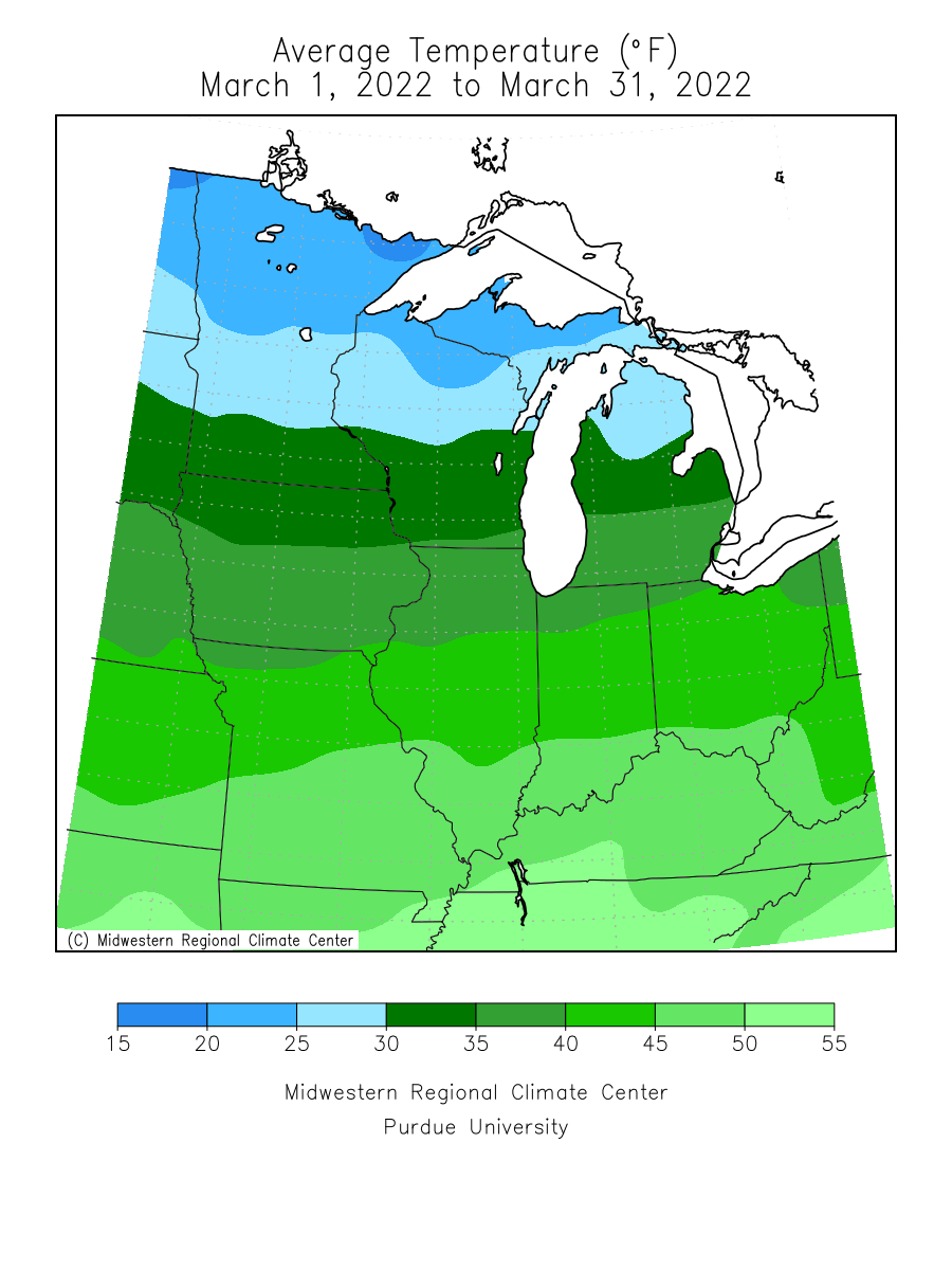
[see: Another wet, slushy, and icy storm, March 29-30, 2022] - Unlike 2020 and 2021, March 2022 finished with below normal temperatures. It was the third month in a row to finish below normal with a preliminary statewide average of 27.5 degrees or 1.2 degrees below normal. Despite the fact March finished cool there was a burst of mild temperatures with 50s, 60s and even a rouge 70 degree reading during the third week of the month. The warmest temperature found was 71 degrees at Pipestone on the 21st and the coldest temperature was -29 degrees F at both Kabetogama and Tower 2S on the 12th. [see: Minnesota Climate Trends | March climate Summary Table | 2022 March Temperature Map]
Where we stand now:
- Winter overstayed its welcome in early April. The snow depth map of April 7, won’t be the last as a fairly robust snowpack hangs on in the far north and northeast
[see: MNDNR April Snow Depth Maps | NWS Snow Depth Estimation Map | Midwest Regional Climate Center Snow Depth Map] - The U. S. Drought Monitor map released on April 7, 2022 depicts 52% of the state with some level of drought designation. Last year at this time, 85% of the state had some level of dryness indicator. On April 7, 2022 about 43% of the state was Abnormally Dry, and 10% of the state in Moderate Drought conditions. Ample March and early April rains (and snow) has continued the gradual improvement that began in the fall of 2021. The U.S. Drought Monitor index is a blend of science and subjectivity where drought categories (Moderate, Severe, etc.) are based on several indicators.
[see: Drought Conditions Overview] - The 2022 spring flood season due to snowmelt (at least so far) was fairly on the quiet side. On April 8, most rivers in the state were in the normal range, with a few areas in the west central parts of the state in the “much above normal” range. On April 8, the Red River of the North was peaking at Wahpeton in the minor flood stage and was on the rise downstream from Fargo to Pembina.
[see: Statewide USGS Stream Flow Conditions | Central Minnesota Rivers | Southeast Minnesota Rivers | Northwest Minnesota Rivers, including the Red River - Water levels on most Minnesota lakes vary depending on lake and location. The benchmark lakes were ice covered in early April so water levels are preliminary. Mille Lacs was frozen down to the water sensor, so there is no current level. A preliminary Minnetonka level was at 928.55 feet on April 8, with Grays Bay Dam closed. White Bear Lake had a preliminary level of 923.67 feet on April 8. Rainy Lake and Lake of the Woods were both in the median range for early April. Lake Superior was forecasted to be at 600.95 feet on April 8, two inches lower than the long term monthly average for early April and eleven inches below the level in early April 2021. Superior is forecasted to rise over the next month.
[see: Mille Lacs Lake Water Level | Lake Minnetonka Water Level | White Bear Lake Water Level | Lake of the Woods Control Board Basin Data | Corps of Engineers Great Lakes Water Levels] - In its first report of the 2022 growing season, the Agricultural Statistics Service reported that topsoil moisture across Minnesota was 4 percent Very Short, 11 percent Short, 66 percent Adequate, and 19 percent Surplus. This is wetter than the same time last year. Cool and damp conditions prevented fieldwork across the state.
[see: Agricultural Statistics Service Crop Progress and Condition] - The cool and wet conditions are keeping fire danger low. The potential for wildfires is currently rated by DNR Forestry as Low across the entire state. Historically, 80 percent of all wildfires in Minnesota occur during April and May.
[see: Fire Danger Rating Map] - Lake ice out began in late March, and so far is running from a few days to a week behind. An April 8, many lakes south of the Twin Cities have opened up, with the smaller lakes in the Twin Cities partially covered.
[see: 2022 Lake Ice-Out Dates | DNR Conservation Officer Reports]
Future prospects:
- The April precipitation outlook indicates a greater than average chances of above-normal values across all but the far western parts of the state. Through April 8, the statewide precipitation average is showing a .34 inch surplus. Normal April precipitation ranges 1.5 inches in northwest Minnesota to around three inches in southeast counties. The historical probability of measurable precipitation for any given day in April ranges from 20 percent in the far northwest to 35 percent in the southeast.
[see: Climate Prediction Center 30-day Outlook | April Precipitation Normal Map] - The April temperature outlook favors equal chances for below, normal and above normal temperatures. Through April 8 the average Minnesota temperature departure was 3.6 degrees below normal. Normal April high temperatures are in the mid to upper 40s early in the month, rising to the low 60s by month's end. Early-April normal low temperatures are near 20 in the north, near 30 in the south. By month's end, low temperatures average in the mid-30s in the north, near 40 in the south.
[see: Climate Prediction Center 30-day Outlook | April Temperature Normal Map] - The 90-day precipitation outlook indicates equal chances of below, normal and above normal precipitation from April-June The April through June temperature projection favors above normal conditions over all but northwest Minnesota.
[see: Climate Prediction Center 90-day Outlook]
From the author:
The frost left the soil on April 6 in Maplewood, just north of St. Paul and fits the progression of spring, behind 2020 and 2021 but earlier than 2018 and 2019.
[see: Signs of Spring: Phenology ]
Upcoming dates of note:
- April 21: National Weather Service releases 30/90 day temperature and precipitation outlooks
![]() Subscribe to email announcements of the monthly posting of this product.
Subscribe to email announcements of the monthly posting of this product.
Pete Boulay MNDNR Climatologist