A monthly electronic newsletter summarizing Minnesota's climate conditions and the resulting impact on water resources. Distributed on the first Thursday of the month.
State Climatology Office - DNR Division of Ecological and Water Resources, St. Paul
distributed: July 13, 2022
What happened in June 2022:
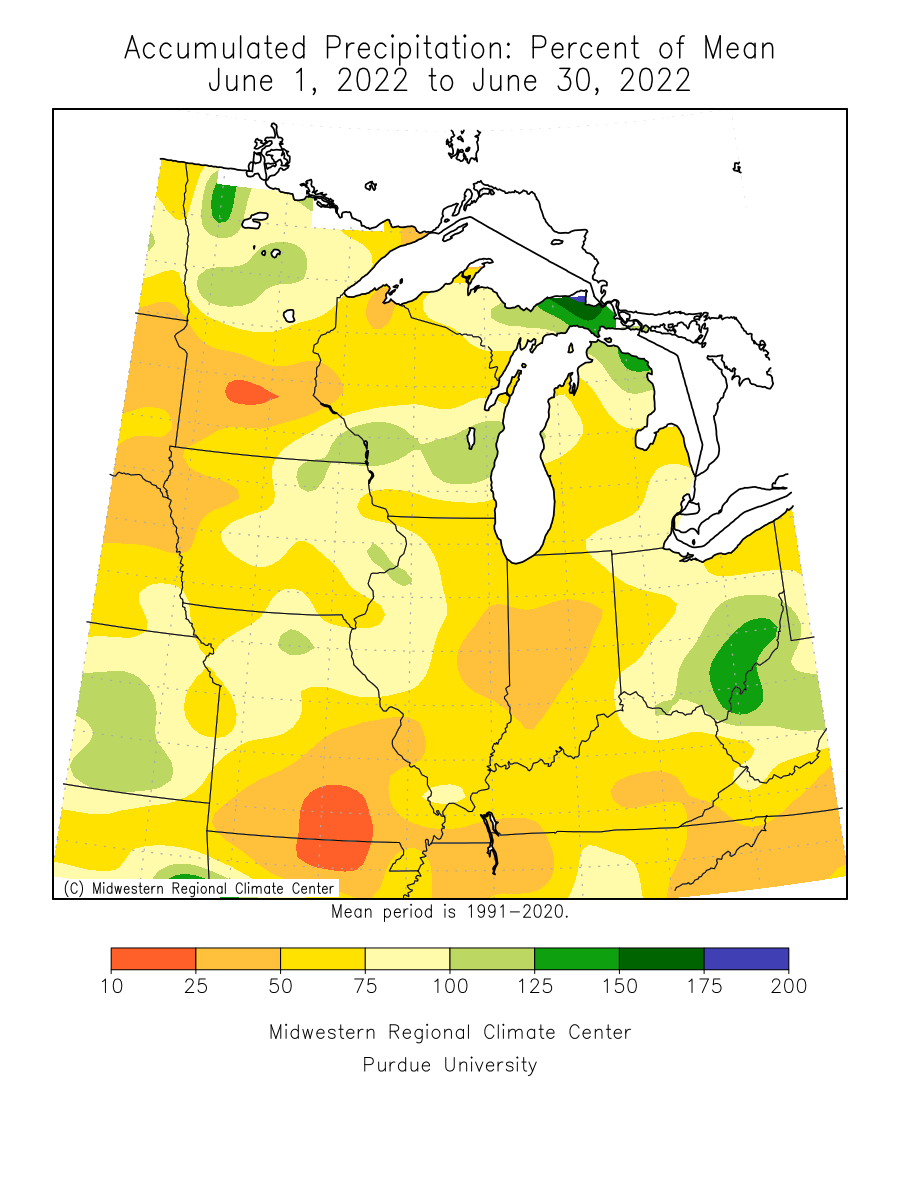
- June 2022 was a drier than normal month in the state. About 75% of the state had below normal precipitation during the month. The Twin Cities finished with 1.13 inches of rain for the month, which is only 25% of what would normally fall, and the fifth-lowest June total out of 152 years with precipitation records. Many stations in western, central, and southern Minnesota received under an inch of rain for the month, and had less than 20% of normal precipitation. On a statewide averaged basis, a typical station was 30-40% below normal. One of the wettest monthly totals reported by a National Weather Service Cooperative Observer was 7.51 inches, or 2.96 inches above normal at Ottertail in Otter Tail County. Also of note was the isolated, but extreme rainfall in Morrison County on June 23-24 where a Mngage observer near Cushing had their 11inch rain gage overflow. A CoCoRaHS reader near Randall had 7.40 inches. One of the direst locations was Dassel in Meeker County with only .53 inches of precipitation or 3.80 inches below normal.
[see: June 2022 Precipitation Total Map | June 2022 Precipitation Departure Map | June 2022 Climate Summary Table | June 2022 Percent of Normal Precipitation Map] - There were three severe weather events of note in June 2022. In the wake of the extreme heat of Monday, June 20 waves of thunderstorms caused damage across large areas of central and northern Minnesota. Semi-trailers were blown off the road near Oklee in Red Lake County, with power poles toppled and wind-driven large hail damaging crops in Polk County. The deadliest of the day's storms entered far western Minnesota around 11 PM, moving into the Alexandria area after 11:30. A man from Arizona was killed and his wife hospitalized after storms hit a resort on the west side of Lake Mary, in Douglas County, blowing a tree onto the couple's camper. A 91mph gust was measured at Mallory in Polk County.
[see: Another Round of Destructive Storms, June 20-21, 2022 ] - A concentrated area of regenerating and slow-moving heavy thunderstorms in central Minnesota produced large hail and the state's most extreme rainfall to date from the evening of Thursday June 23 into the morning of June 24, 2022. Brainerd, in particular, endured quite a barrage of hail, with half dollar, ping pong ball, golf ball-sized, and even larger hail hitting many places multiple times over a three-hour period. Large hail also fell near Aitkin, Big Sandy Lake, and later near St. Cloud. Just after sunrise on Friday, separate intense storms developed in Otter Tail County, producing tennis ball-sized hail in Battle Lake and baseball-sized hail near Ottertail just before 7 AM. Rain totals well in excess of three inches fell northwest of Little Falls, and also in St. Cloud and neighboring communities. A small area near Randall and Cushing received extraordinary rainfall totals, leading the closure of US Highway 10 in both directions because of flooding in the area.
[see: Hail and Heavy Rain in Central Minnesota, June 23-24, 2022] - Another episode of hail, damaging winds, and tornadoes lashed portions of northwestern and northern Minnesota during the evening and overnight hours of Friday June 24 into early Saturday June 25, 2022. The storms produced at least two confirmed tornadoes within pockets of damaging wind gusts over 70 mph, including an 88 mph gust measured in East Grand Forks, and 83 mph measured near Lengby in Polk County. The National Weather Service confirmed that an EF-2 tornado tracked 31 miles through parts of Becker and Wadena counties around and just after 10 PM, with winds estimated to 115 mph and a maximum width of 600 yards (about a third of a mile). Another EF-1 tornado was confirmed to have struck Naytahwaush in Mahnomen County about 45 minutes to an hour earlier.
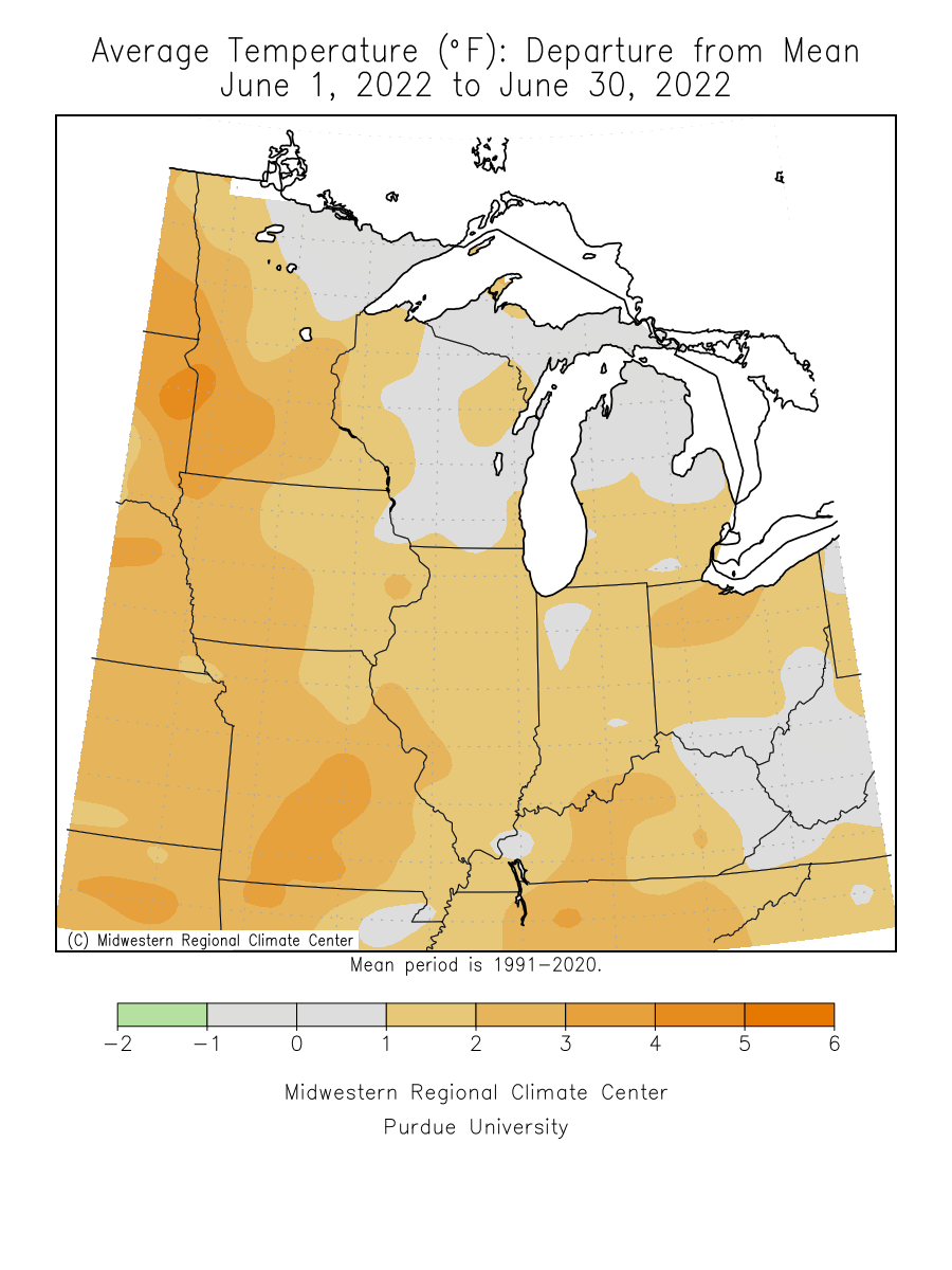
[see: More Damaging Thunderstorms, June 24-25, 2022] - June was a warm month, but not as warm as June 2021. The preliminary statewide average temperature for June 2022 was 67.5 degrees or 1.8 degrees above normal. It was a changeable month, with several cool periods interrupted by spells of heat that generally grew longer and more intense the farther south one went. The most notable heat occurred on June 19 and 20th when temperatures reached or exceeded 100 degrees F in many locations. The Twin Cities saw a high of 101 degrees on June 20. This was the first time the mercury has cracked the century mark in the Twin Cities since Memorial Day, 2018. The warmest temperature reported in Minnesota was 102 degrees at the St. James Waste Water Treatment Plant. Due to the time of observation at that site, the maximum temperature was reported on the 21st, but occurred on the 20th. The coldest temperature reported for the month was 29 degrees at Celina on June 5 in northeast Minnesota.
[see: June 2022 Climate Summary Table | 2022 June Departure from Normal Temperature Map]
Where we stand now:
- Seasonal precipitation so far (April 1 through July 12) shows a spilt state with normal to dry conditions in the central and south and above normal precipitation in the north. The exceedingly wet spring in the north still shows up with rankings in the 99th percentile for parts of Northwest and north central Minnesota. The driest locations are from the Twin Cities to Nicollet County were some spots are below the 20th percentile.
[see: Seasonal Precipitation Maps] - The U. S. Drought Monitor map released on July 5 depicts .5% of the state in Moderate Drought conditions and 17% of the state in Abnormally Dry conditions. The U.S. Drought Monitor index is a blend of science and subjectivity where drought categories (Moderate, Severe, etc.) are based on several indicators.
[see: Drought Conditions Overview] - The U.S. Geological Survey reports that stream discharge levels vary quite a bit in the state, ranging from much above normal to below normal. The majority of streams are in the “normal” range with the highest stream-flow reports along the Canadian border and in areas of northwest and west central Minnesota. A few of the smaller streams in eastern Minnesota have below average stream flows.
[see: Cooperative Stream Gauging | USGS Stream Flow Conditions] - Water levels on Minnesota lakes vary depending on lake and location in the state. On July 13, Mille Lacs was at 11.72 feet, about two tenths higher than the median and about six-tenths of a foot higher than July 2021. On July 11, Minnetonka was at 928.78 feet with 12 cfs flowing through Gray's Bay Dam. White Bear Lake was at 923.71 feet, a fall of four tenths (.4) from July 2021. Rainy Lake was falling from its record peak level set in June, but continues to be much above the median level. Lake of the Woods was reaching its peak in July, above the 2014 peak level, but falling short of the 1950 peak level. Lake Superior was at 602.46 feet on July 8, four inches above the July average.
[see: Mille Lacs Lake Water Level | Lake Minnetonka Water Level | White Bear Lake Water Level | Lake of the Woods Control Board Basin Data | Corps of Engineers Great Lakes Water Levels] - The Agricultural Statistics Service on July 11 reported that topsoil moisture across Minnesota is 3 percent Very Short, 12 percent Short, 75 percent Adequate, and 9 percent Surplus. Soil moisture levels at Lamberton on July 1 were below historical averages. The soil moisture was approximately 5 inches, a drop of 2.5 inches since June 15. The dryness is mostly confined in the top two feet of the profile.
[see: Agricultural Statistics Service Crop Progress and Condition | U. of M. Southwest Research & Outreach Center (Lamberton) | 2011-2018 Lamberton Soil Moisture Graphs ] - Compared to 2021, the Spring and Summer 2022 has not been an active season for wildfires. The potential for wildfires is currently rated by DNR Forestry as Low across northern, central and southeast Minnesota, with Moderate fire danger over southwest, south central and along the border of Wisconsin in eastern central Minnesota.
[see: Fire Danger Rating Map]
Future prospects:
- The July precipitation outlook has equal chances of above, normal and below normal precipitation. July precipitation normals range from just under three inches in northwest Minnesota to about five inches in southeastern counties.
[see: Climate Prediction Center 30-day Outlook | July Precipitation Normal Map] - The warm summer continues with July temperature outlook weighted to be above normal, especially in the southwest part of Minnesota. Normal July high temperatures are in the 80s in the south and the upper 70s in the north. Normal July low temperatures are in the 50s in the north, and in the 60s in the south.
[see: Climate Prediction Center 30-day Outlook ] - The 90-day precipitation and temperature outlook for July through September indicates a tendency for dry and warm conditions. The only exception may be in northwest Minnesota where there are equal chances for above, normal and below normal temperature. Looking ahead to the winter of 2022-23, there are equal chances of below, normal and above normal temperatures and the same with precipitation.
[see: Climate Prediction Center 90-day Outlook | Dec-Jan_Feb 2022-22]
From the author:
- A dissipating thunderstorm drifting to the northeast across western Minnesota early in the morning of June 14, 2022 caused a "Heat Burst" at Tracy, MN. A Heat Burst occurs when there is a sudden increase in surface temperature associated with a dying thunderstorm or a shower. When a thunderstorm or shower begins to weaken, and there is a hot and dry atmosphere in place, the downdrafts can accelerate. The remaining moisture dries up causing adiabatic (or compressional) warming. The Heat Burst occurs when this air reaches the surface. It can increase the temperature rapidly like it did in Tracy from 4:55-5:15AM. The air temperature warmed ten degrees from 81 to 91, the dew point temperature fell from 65 to 39 and there was a wind gust to 52 mph. [see: Heat Burst at Tracy, MN June 14, 2022]
Upcoming dates of note:
- July 21: National Weather Service releases 30/90-day temperature and precipitation outlooks