A monthly electronic newsletter summarizing Minnesota's climate conditions and the resulting impact on water resources. Distributed on the first Thursday of the month.State Climatology Office - DNR Division of Ecological and Water Resources, St. Paul
distributed: February 11, 2022
 Subscribe to email announcements of the monthly posting of this product.
distributed: February 11, 2022
What happened in January 2022:
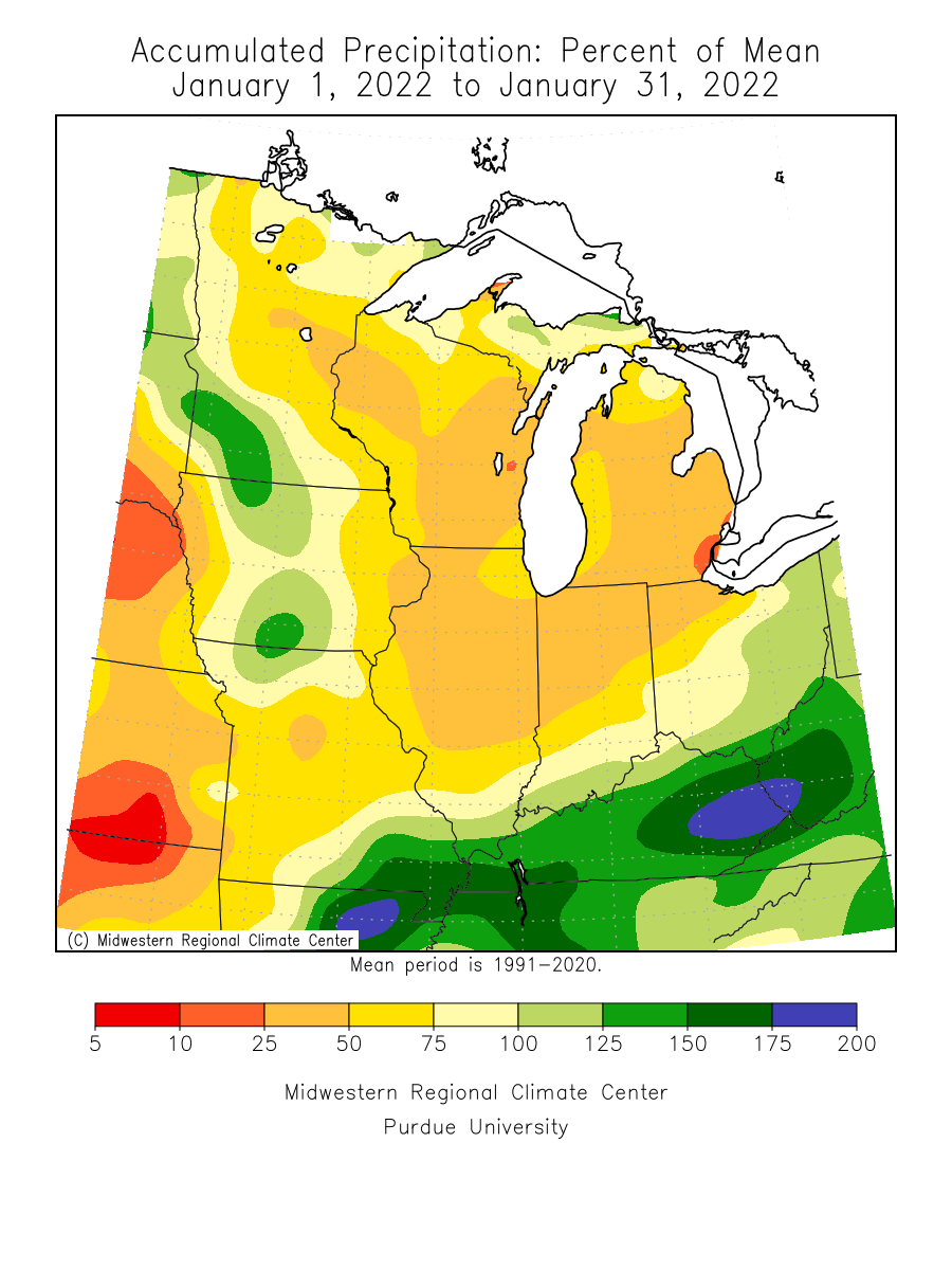
- January 2022 was a month of close to normal to above normal precipitation in the north and south, with below normal precipitation in the central. One of the wetter locations compared to normal was 12 miles NNW of Goodridge in Marshall County with 1.42 inches or .68 inches above normal. Minneota in southwest Minnesota had 1.27 inches or .75 inches above normal. One of the drier locations was Grand Meadow in southeast Minnesota with .32 inches or .70 inches below normal. The preliminary statewide precipitation average for January 2022 was .65 inches or 0.20 inches below normal. In comparison, statewide precipitation for January 2021 was also a little below normal.
[see: January 2022 Precipitation Map | January 2022 Precipitation Departure Map | January 2022 Climate Summary Table | January 2022 Percent of Normal Precipitation Map] - The precipitation events for January 2022 came in the form of a parade of clipper-type systems though the month. The largest of which was a “Super Clipper” on January 14, that brought six to eleven inches of snow to western and south central Minnesota.
[see: Super Clipper, January 14, 2022] - A classic "prairie blizzard" swept through North Dakota and into the open areas of northwestern Minnesota, producing whiteout conditions in the Red River Valley. It’s been an active blizzard season so far in 21-22. This was the seventh blizzard warning for parts of the Red River Valley this season so far.
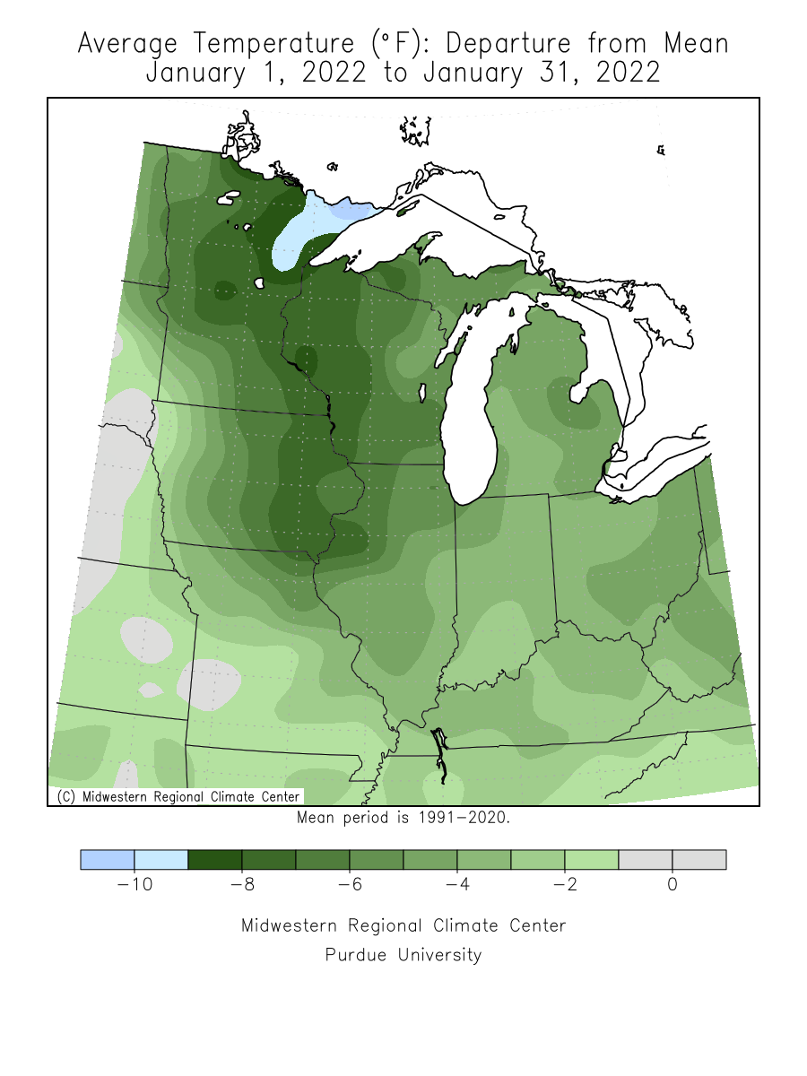
[see: Northwest Minnesota Blizzard, January 31 to February 1, 2022] - Temperatures for January 2022 were much colder than normal. It was the first month to finish below normal in the state since February 2021. It was a month of rollercoaster temperatures, with more dips than rises. The preliminary statewide average temperature for January 2022 was 5.3 degrees or six degrees below normal. This was thirteen degrees cooler than January 2021. The warmest temperature of January 2022 was 50 degrees at Lakefield on the 12th and the coldest temperature of the month was -44 degrees at Baudette and Warren on January 1.
[see: January 2022 Climate Summary Table | January 2022 Departure from Normal Temperature Map
Where we stand now:
- As of February 10, snow depth readings are a little bit deeper than the historical median across most of west central and northern Minnesota, near the median across central Minnesota and near to below the median in the south. The snow is especially scarce in the southwestern part of the state, where there is little to any snow cover. The deepest snow is in its typical location, in the highlands of Lake Superior where snow depths are three feet in some locations. There is also deep snow along the Canadian Border from Pembina to Grand Portage.
[see: Weekly Snow Depth and Ranking Maps | NWS Snow Depth Estimation Map | Midwest Regional Climate Center Snow Depth Map] - The U. S. Drought Monitor map released on February 11, 2022 depicts 70% of the state with some level of drought designation. About 31% of the state was Abnormally Dry, and 32% of the state in Moderate Drought conditions. Northern Cook and Lake Counties have Severe Drought conditions. The U.S. Drought Monitor index is a blend of science and subjectivity where drought categories (Moderate, Severe, etc.) are based on several indicators.
[see: Drought Conditions Overview] - The U.S. Geological Survey reports that stream discharge values (where winter measurements are possible) range from normal to much above normal. Few Minnesota rivers have stream flow data. Most rivers and streams are now impacted by ice.
[see: USGS Stream Flow Conditions] - In their final report of the 2021 growing season (November 29), the Agricultural Statistics Service reported that topsoil moisture across Minnesota was 2 percent Very Short, 11 percent Short, 80 percent Adequate, and 7 percent Surplus, there is a little more topsoil moisture noted at freeze-up 2021 than in 2020.
[see: Agricultural Statistics Service Crop Progress and Condition | U. of M. Southwest Research & Outreach Center (Lamberton) | U. of M. Southern Research & Outreach Center (Waseca)] - The potential for wildfires is currently rated by DNR Forestry as Low across Minnesota.
[see: Fire Danger Rating Map] - Soil frost depths are about average to slightly above average for early February, depending on snow cover. Frost depths are generally a foot to two feet over southern Minnesota to 18-32 inches across the north. One outlier is frost depth of 6 inches at Long Prairie under a deep snowpack. Soil temperatures at the U of M St. Paul Campus Climate Observatory have stayed near 31 degrees at the four inch depth throughout much of the winter.
[see: National Weather Service Frost Depth Data | MnDOT Road Frost Depths | University of Minnesota - St. Paul Campus Soil Temperatures Under Sod] - Lake ice in started early due to the cold conditions in mid-November, but mild conditions that followed caused some lakes to thaw and to refreeze again. Some lakes stayed frozen, others had multiple freeze-thaw dates. In general lakes froze over for good with an arctic outbreak on December 6-7 and many lakes that still had open water froze at that time or shortly thereafter.
[see: DNR Conservation Officer Reports | 2021 Lake Ice-In Dates | Great Lakes Ice Cover]
Future prospects:
- The February precipitation outlook has a tendency for above normal precipitation in the north, the same areas most favored by the Alberta Clippers over the past six weeks. There are equal chances for above blow and normal precipitation over the central and south. Precipitation normals range from near one-half inch of liquid equivalent in western Minnesota to just over three-quarter of an inch of precipitation in eastern sections of the state. The median snow depth at the end of February ranges from under five inches in southwest Minnesota to over 18 inches on the ground in northeastern Minnesota (greater than 30 inches in the Lake Superior highlands).
[see: Climate Prediction Center 30-day Outlook | February Precipitation Normal Map] - The February temperature outlook has a tendency for below normal temperatures. As of February 11, the preliminary average temperature for February in Minnesota is 2.8 degrees below normal, with the roller-coaster ride of temperatures continuing. Could February be the second month in a row to finish below normal? Stay tuned. Normal February high temperatures range from the low teens in the north to near 20 in the south early in the month, climbing to the mid-20s to low 30s by month's end. Normal February low temperatures range from near minus 10 degrees in the far north to the single digits above zero in southern Minnesota early in the month; ascending to the low single digits in the north, mid-teens in the south by the end of February.
[see: Climate Prediction Center 30-day Outlook | February Temperature Normal Map] - The 90-day precipitation outlook for February through April indicates a tendency for above normal precipitation in eastern Minnesota with equal chances for above and below normal precipitation for the rest of the state. The February through April temperature projection indicates equal chances for below, normal and above normal temperatures.
[see: Climate Prediction Center 90-day Outlook] - The National Weather Service produces long-range probabilistic river stage and discharge outlooks for the Red River, Minnesota River, and Mississippi River basins. These products address both high flow and low flow probabilities. Here are the current weather conditions impacting prospects for spring snow melt flooding:
- As February 10, the snow water equivalent on the landscape is below average in the southwest, about average in the central part of the state, and near to above average in the north. The drought that began in 2020 continues into 2022, but is much reduced in areas like the Red River Basin. The Minnesota River basin is free of drought. Moderate drought continues in parts of the Upper Mississippi. Moderate to severe drought continues in the north central and northeast. There’s also moderate drought in much of the Twin Cities and south central Minnesota. Frost depths across the state are on the higher side of average and are nearing their deepest depths for the season.
- Since the snow water equivalent is running a near to above average in the Red River Basin, the risk for significant snowmelt flooding is moderately high, running to slightly above long-term historical averages across the Red River. The Mississippi Headwaters has slightly above normal readings for snow water equivalent, so that area bears watching. The overall flood threat picture for the Minnesota and Upper Mississippi is average..
- We still have quite a bit of winter to go, so there may be changes to the situation.
From the author:
- A January Thaw is defined as two or more consecutive days with maximum temperatures above 32 degrees F. These thaw episodes are a regular part of Minnesota's climate, bringing a brief respite to a Minnesota winter. January Thaws are most common and often most dramatic in southwestern Minnesota, where the local topography can boost daytime temperatures above freezing with relative ease, and sometimes even above 60 F. Although less extreme, January Thaws also occur most years throughout southern and western Minnesota.
[see: Behold, the January Thaw!]
Upcoming dates of note:
- February 17: National Weather Service releases 30/90 day temperature and precipitation outlooks
- Late-February: National Weather Service releases updated spring flood probabilistic outlooks